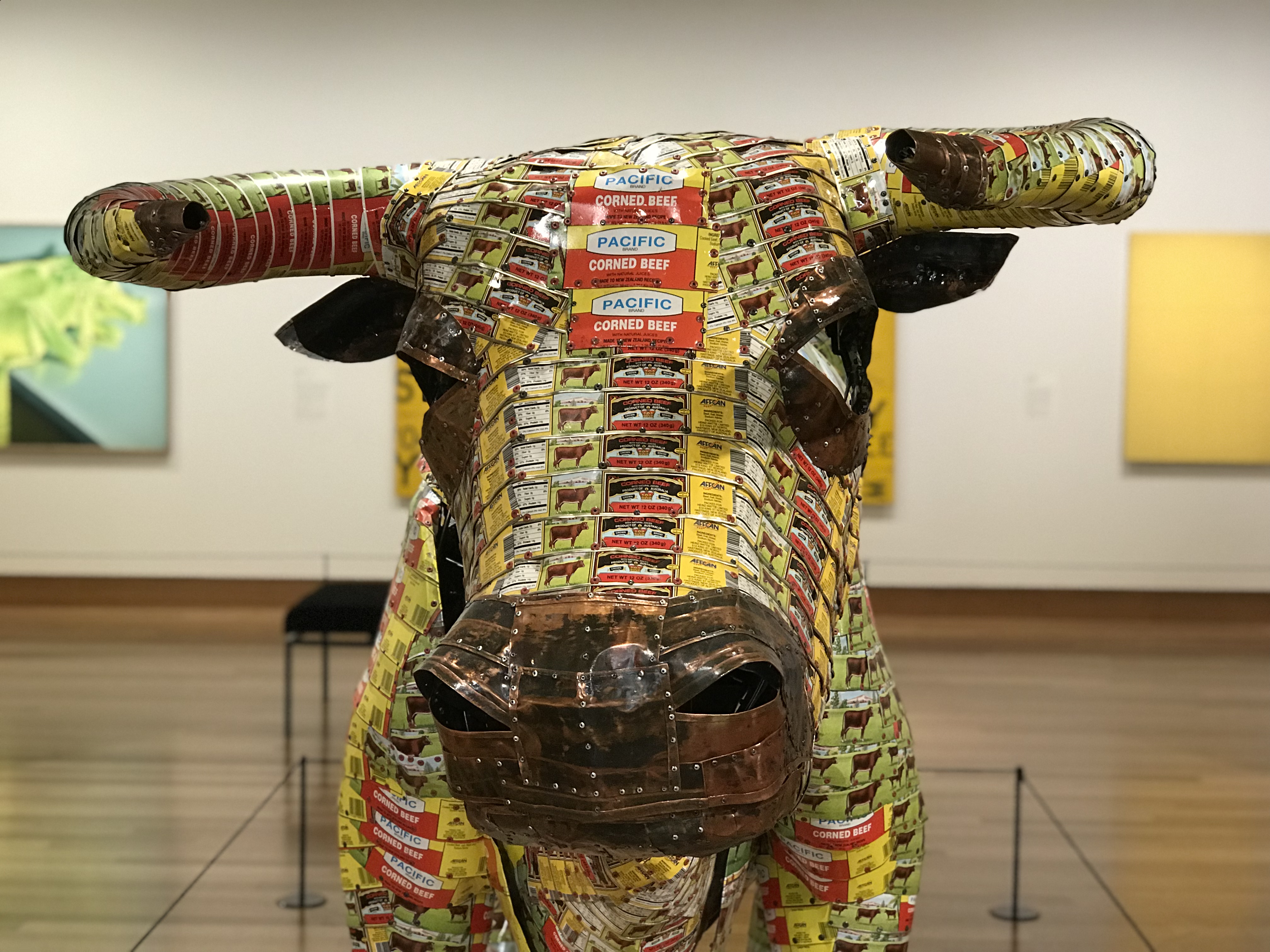
Songlines – Bruce Chatwin which we re-read after visiting the Red centre and Far North
Cicada – Moria McKinnon. Highly recommended and written by a colleague of Paul’s that comes from Western Australia and now lives in Canberra
Island Home by Time Winton and Australia Day by Melanie Cheng both of which Lois discovered during our travels
Movie: That’s Not my Dog! Unfortunately this does not seem to be available on iTunes or Netflix in Canada but if you ever have a chance watch it and you will be surely be laughing out loud. It is a film of a real life party where all of the guests are comedians and the whole production, with some musical interludes, is them telling jokes (rated R)!
In Māori mythology, Rūaumoko is the god of earthquakes, volcanoes and seasons. He is the youngest son of Ranginui (the Sky father) and Papatūānuku (the Earth mother), (commonly called Rangi and Papa). His movements (explained in various stories) account for earthquakes.
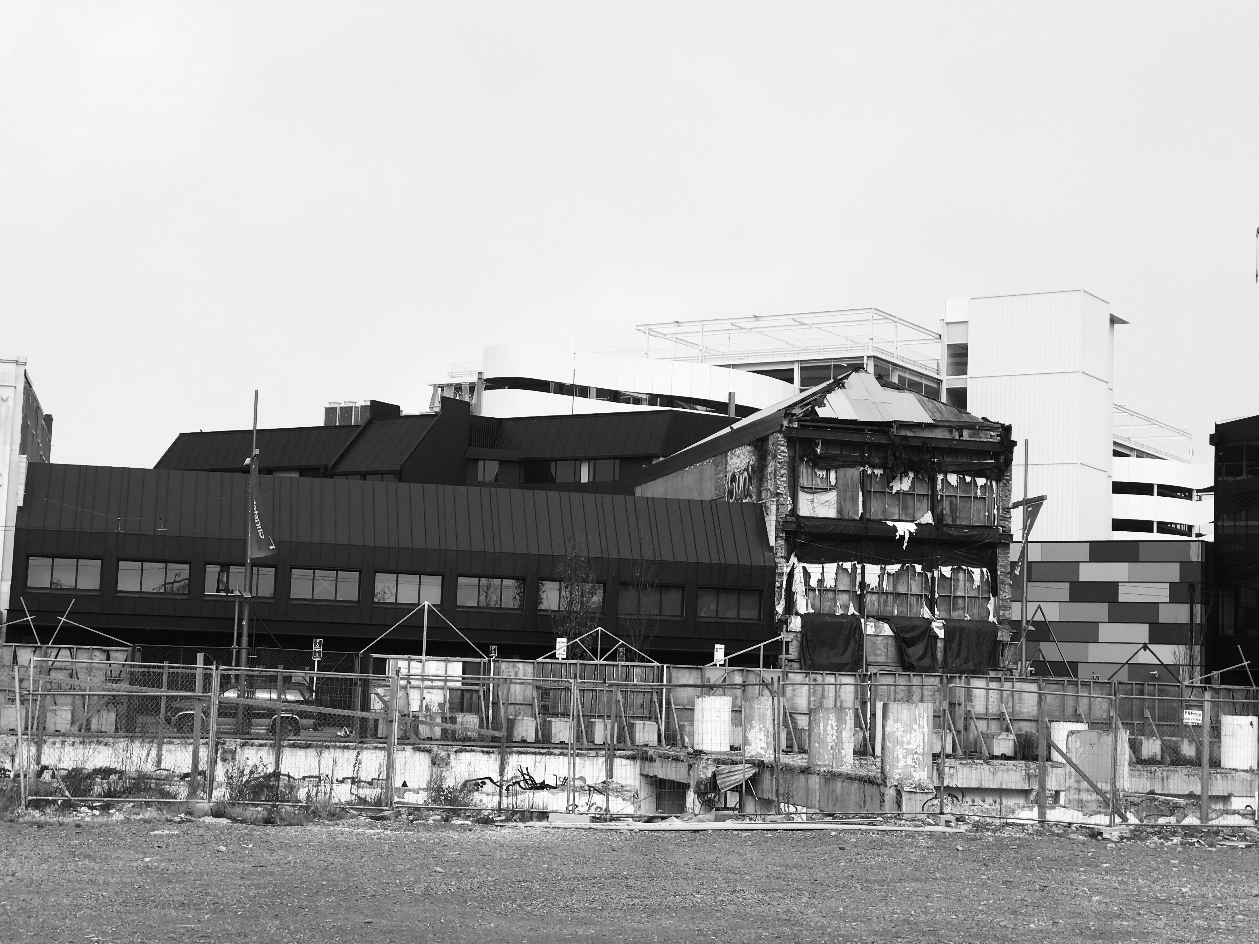
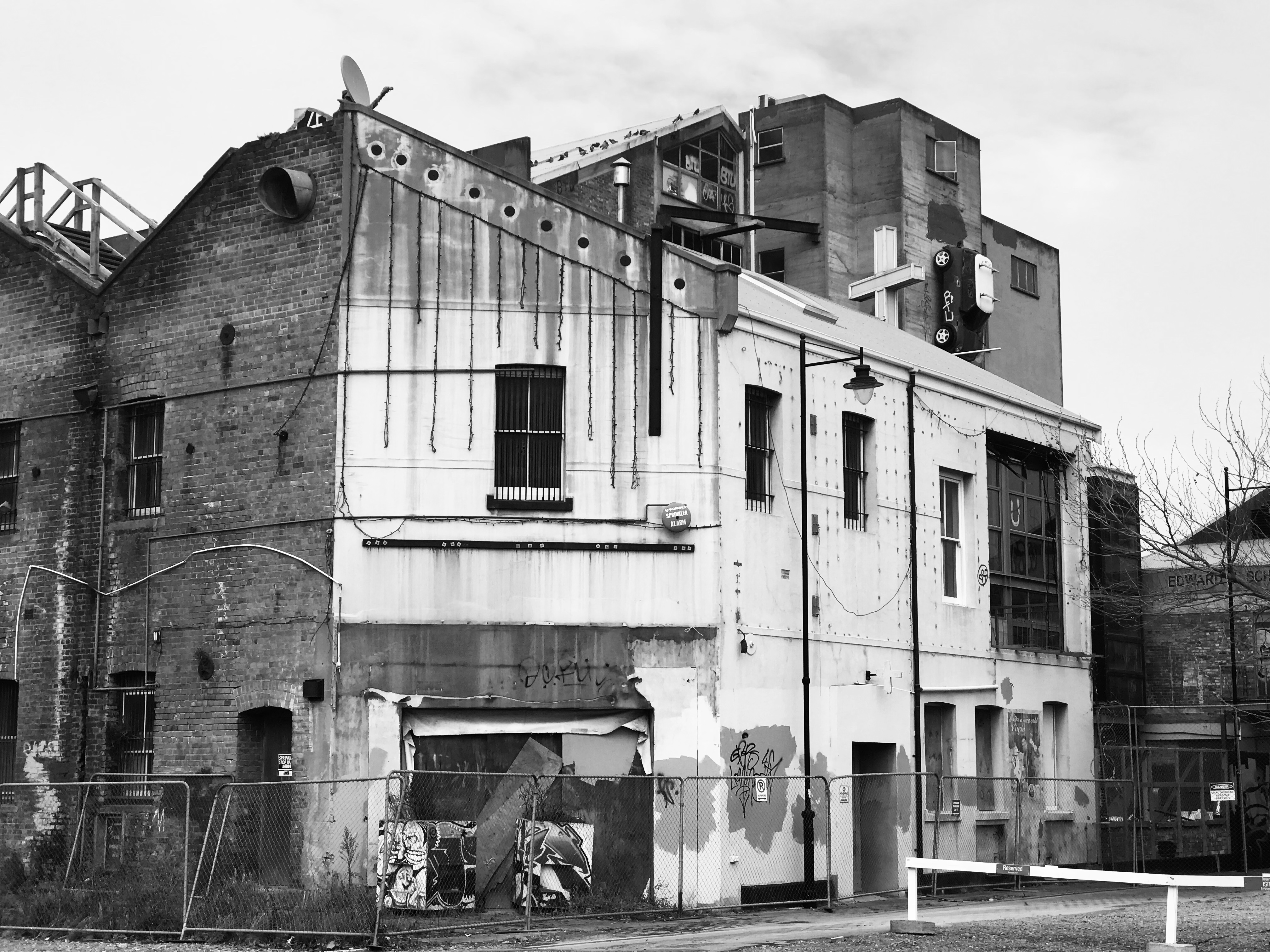
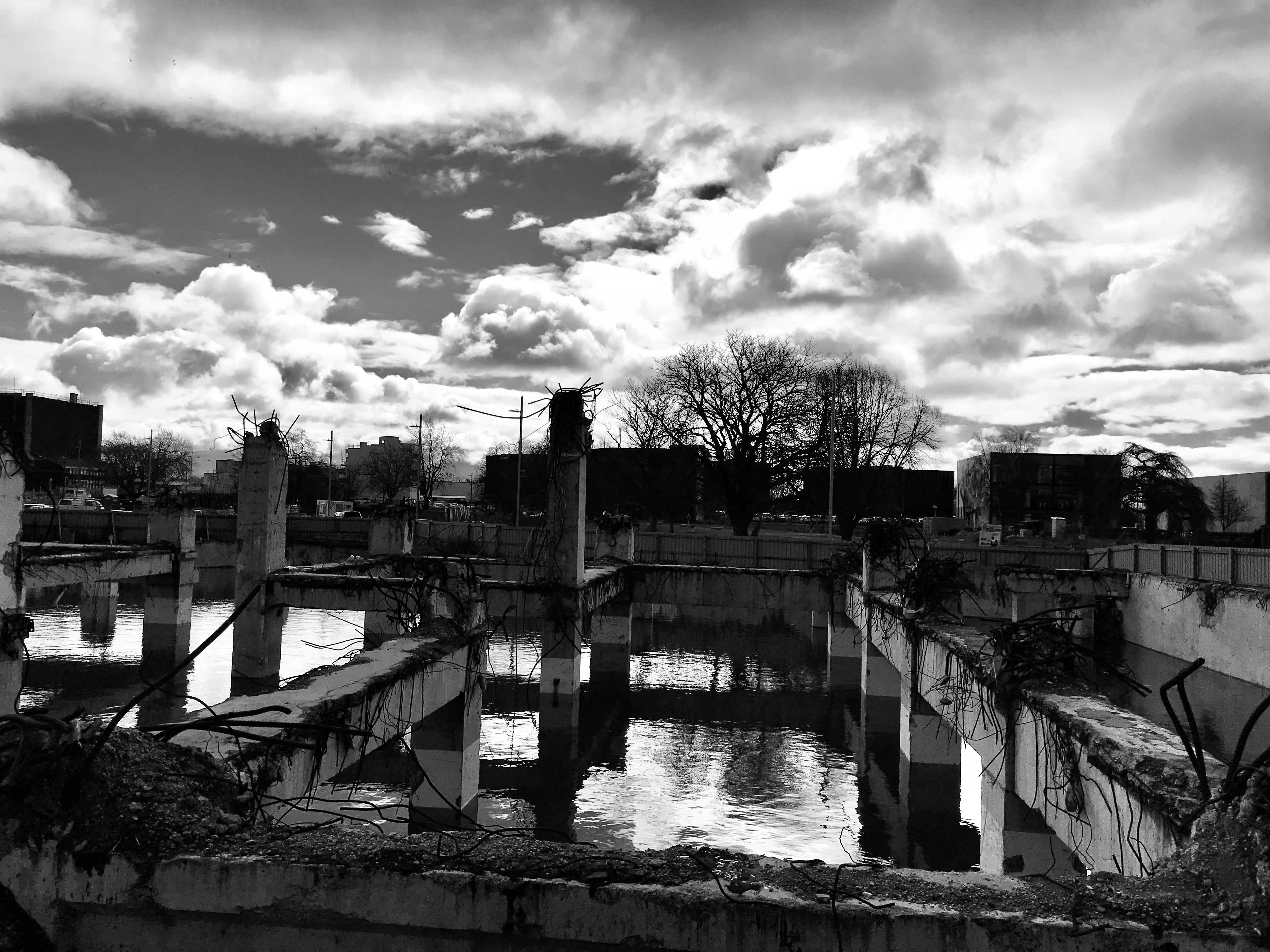
To visit Christchurch is to get some sense of what a city goes through after a major, sudden onset disaster. New Zealand has always experienced earthquakes and the latest series to hit the Canterbury region began September 4, 2010. This quake, which occurred very early in the morning, caused widespread damage to Christchurch and surrounding areas, but no fatalities. A shallower but closer quake shook the city at midday on February 11, 2011, resulting in 185 deaths and major damage to land, buildings and infrastructure, nearly wiping out the old downtown area, where 80% of the buildings were affected. Two more quakes in June and December 2011 caused further damage. The central business district was “red zoned” and cordoned off for 800 days. Seven and one half years later, while life has returned to the city centre, many large buildings, including the Post Office, remain boarded up awaiting removal or reconstruction. Restoration of the historic provincial government seat, shored up by steel girders, is scheduled for 2029. Shipping containers were put to all sorts of uses, creating pop-up coffee shops or piled high to reinforce unsound buildings or to create a temporary mall, the latter now replaced with a brand new shopping centre. A decision to reconstruct the Gothic Revival-style Anglican Christchurch Cathedral has only just been taken, the ruins of this landmark sitting as a painful reminder of the devastation. We were intrigued by the transitional “Cardboard Cathedral”, designed by Shigeru Ban and rapidly constructed using reinforced cardboard tubes, timber and steel, with eight shipping containers forming the walls. Nearby is an outdoor installation of 182 white chairs donated by relatives of those who died. 115 of these deaths occurred when the 6-storey CTV building, declared safe in December 2010, collapsed and caught fire in the February quake.
We spent a fascinating morning in the compact museum, Quake City, learning more about the earthquakes and their impact, including very moving video testimonials from people who were immediately affected. In one video clip, a police officer on duty at the time in the basement of the police station described having to escape with 6 prisoners as the station began to flood. Emerging from the damaged building with the men all handcuffed together, he managed to find a judge standing in a nearby square and quickly organized an ad hoc bail hearing for two of the prisoners, with the terms written out on a paper receipt! When the police station had to be demolished later, 40,000 people ignored the call not to watch the controlled destruction!
It is salutary to think that the Canterbury events were small compared to many others that happen across the globe, and even with all the help and support that a developed country can give, it will still be decades before the city fully recovers. While many residents left while the central district was closed, some have returned however, and, together with workers brought in for the rehabilitation effort, the city’s population is now greater than it was in 2011.
Life goes on and there is great coffee (see below), excellent food and warm hospitality. The Heritage Hotel which had undergone a seismic upgrade in the 90’s, has a lovely bar with a good menu. Christchurch Art Gallery, Te Puna o Waiwhetu, built in 2003, which also survived relatively intact, introduced us to New Zealand artists of the 20th and 21st Century. Above the main stairs is a great piece by Bill Culbert called Bebop, which has a fascinating provenance.
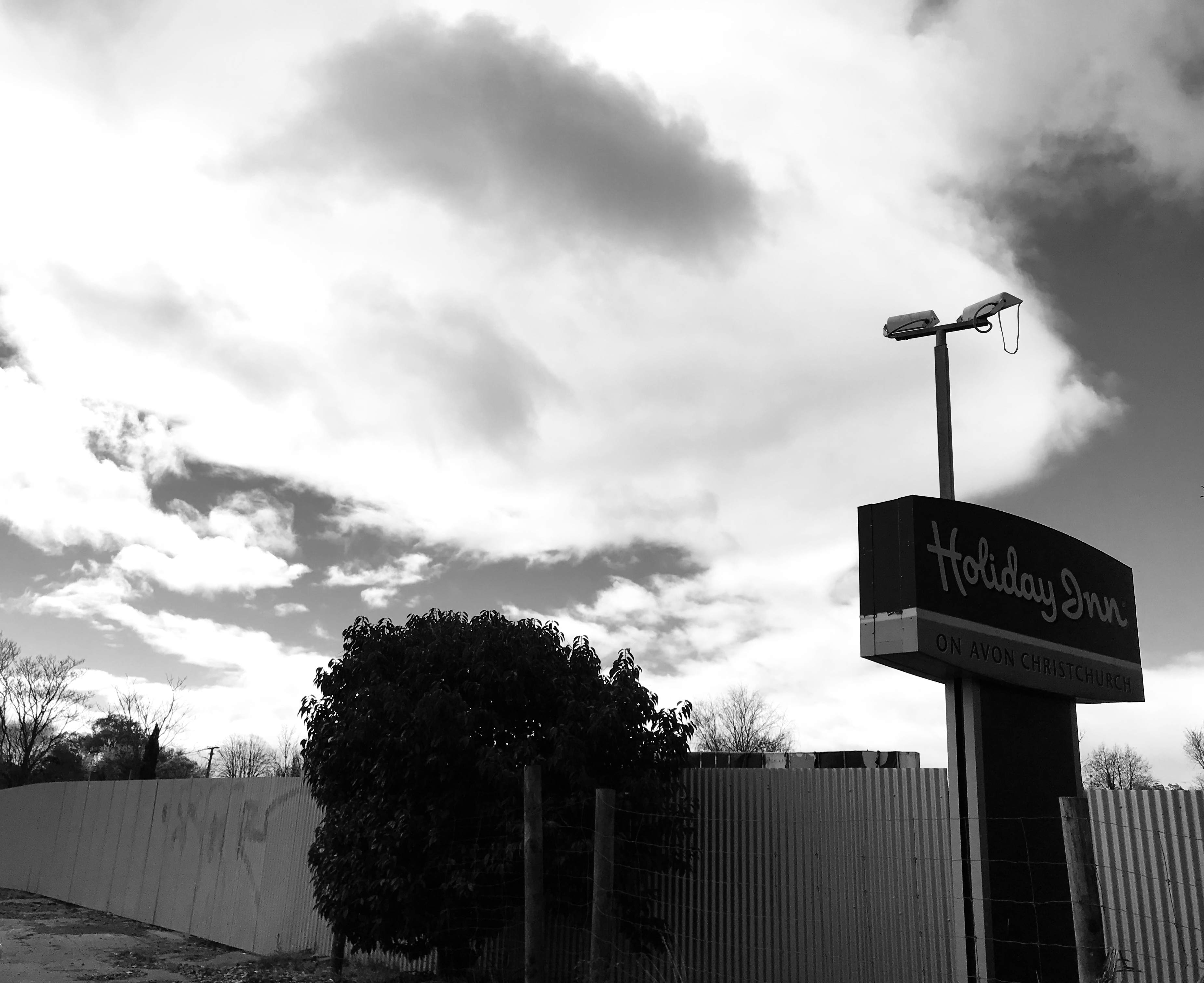
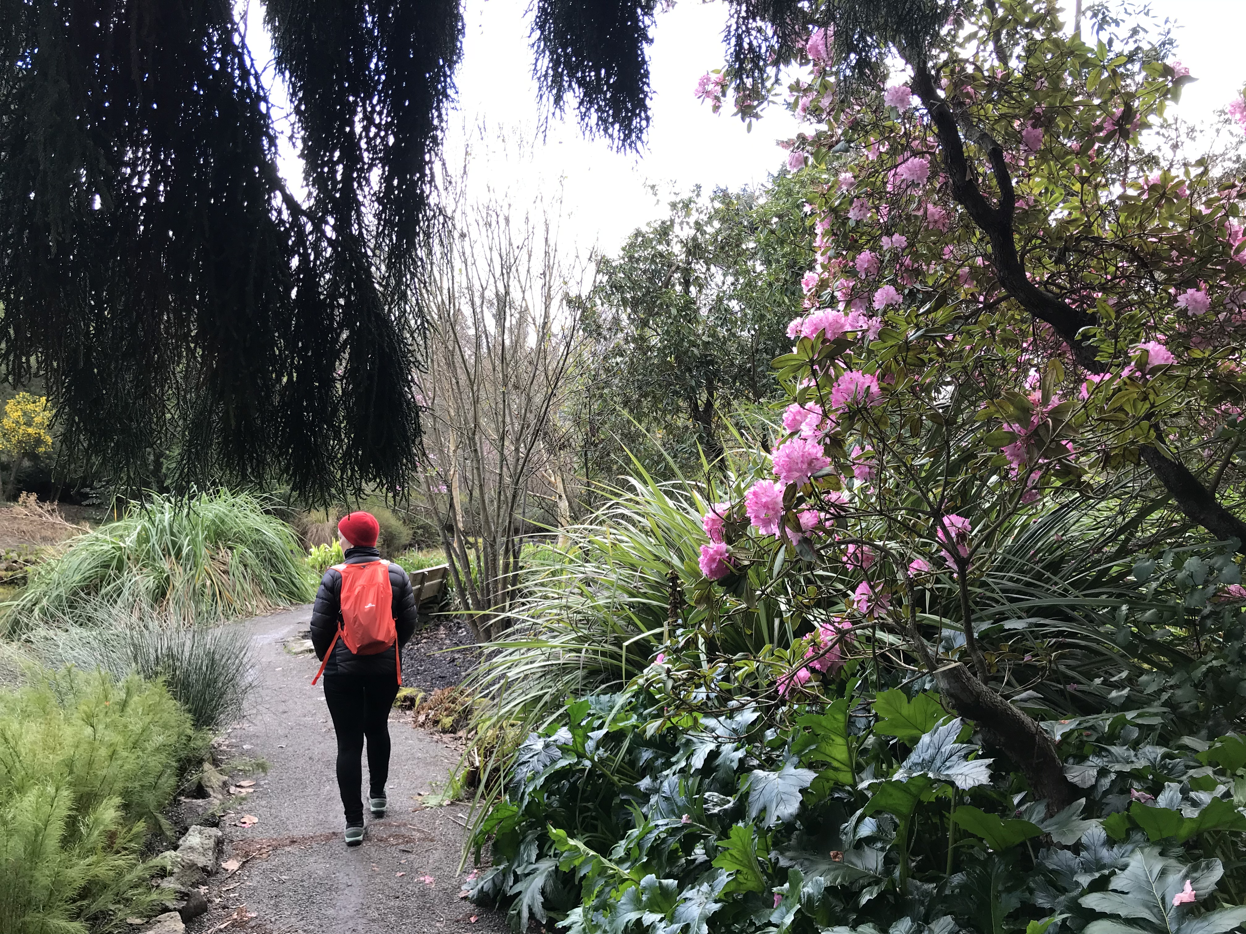
A walk along the Avon River and through the Botanic Gardens was a peaceful contrast to the destruction and rebuilding in the centre, with the exception of the Holiday Inn sign standing alone overlooking the Avon.
Coffee notes: The Caffeine Laboratory: single origin Ethiopian- 9/ 10
C4 Coffee – many locations – 8.5/ 10
The Anglican Cathedral
The Transitional Cathedral
Botanic Gardens
Serious about beer!
Christchurch Art Gallery
Bebop – Bill Culbert
by Juliet Peter
by Buck Nin
by Robyn Kahukiwa
by Lisa Reihana
by Michel Tuffery
by Helen Hitchings
Parkinson’s Disease Note:
Given our findings related to other countries it was not unexpected that we learned that the prevalence of PD in New Zealand is much the same as in other countries. When we were in France we discovered that pesticide exposure is now accepted, for worker’s compensation purposes, to be an occupational risk for PD. In New Zealand we found a news report that exposure to Trichlorethylene, used as a chemical solvent had recently been accepted to be a cause of PD in a veteran who had been a sailor in the New Zealand Navy.
While in Christchurch we read that the effects of the earthquakes on the mental health of persons with PD had been studied using the Hospital Anxiety and Depression Scale. Interestingly no significant differences were found comparing status before and after the earthquakes.
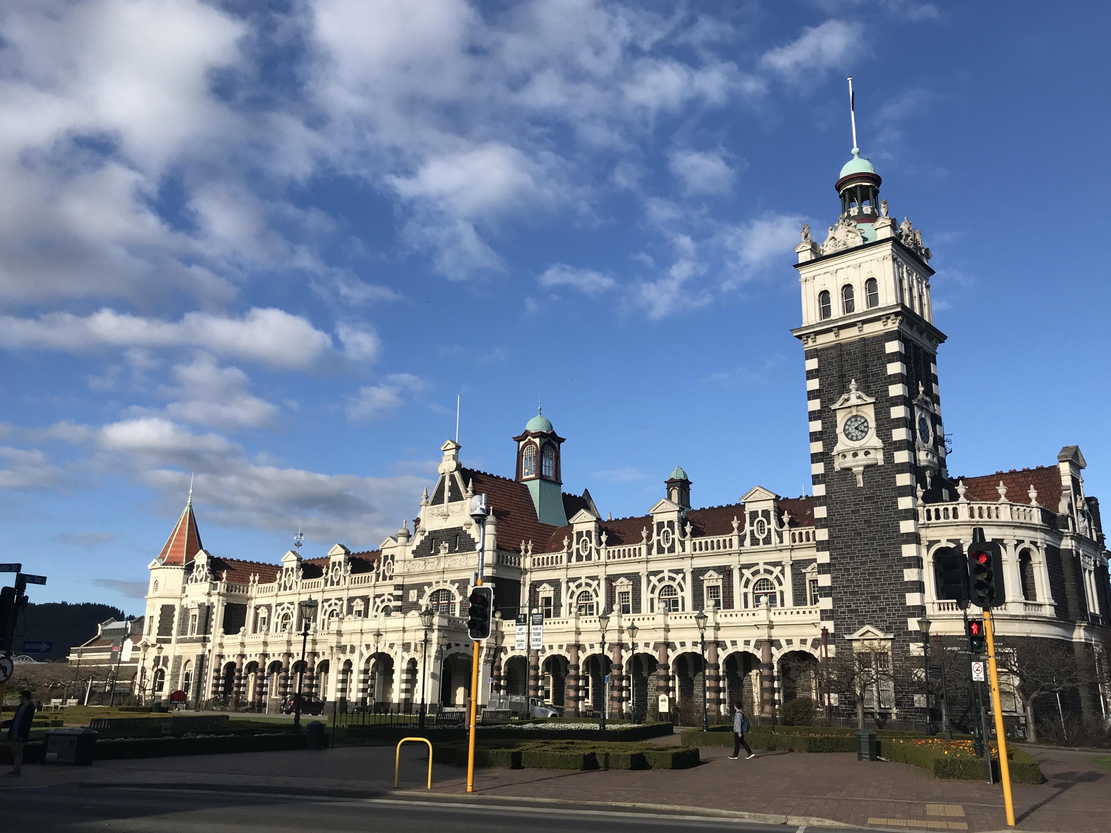
The University of Otago, based in Dunedin, boasts the city has produced many of New Zealand’s greatest novelists, poets, artists, scientists, journalists, musicians, athletes, business people and leaders. Dunedin comes from the Gaelic word for Edinburgh. The city celebrates St. Andrew’s Day and its streets, lined with classic Victorian and Edwardian architecture, are named after streets in the Scottish capital. Prior to the arrival of Europeans, the area had a lengthy occupation by the Ngai Tahu, the principal Māori iwi (tribe) on the South Island. The region of Otago takes its name from the Māori village of Otakou at the mouth of the harbour. Its takiwā (tribal area) is the largest in New Zealand, and extends from Blenheim, Mount Mahanga and Kahurangi Point in the north to Stewart Island in the south. The New Zealand Parliament passed the Ngai Tahu Claims Settlement Act in 1998 to record an apology from the Crown and to settle claims made under the 1840 Treaty of Waitangi. One of the Act’s provisions covered the use of dual (Māori and English) names for geographical locations in the Ngāi Tahu tribal area. Ngāi Tahu actively owns or invests in many businesses throughout the country; tourism, seafood and forestry, and property.
For us, the main draw to the region was the Otago Peninsula. Our guided tour by Elm Wildlife Tours (we were a group of about 10) took us out of Dunedin, past Port Chalmers (which will be visited by over 130 large cruise ships next season), to Taiaroa Head and the Royal Albatross Centre. On the way. Shaun, our guide, talked about Dunedin’s history. During the land wars, Maori prisoners from Taranaki on the North Island were brought to Dunedin as forced labour between 1869 and 1881. The Maori prisoners came in waves, with the first group of 74 – known as the Pakakohe group – sent to Dunedin in 1869 after Titokowaru’s War, an armed dispute in the mid-to-late 1860s, sparked by land confiscations in south Taranaki. The prisoners were held at Dunedin prison and transported to work sites on many city projects, including the Dunedin Botanic Garden’s stone walls. They were eventually followed by 137 of Te Whiti’s “ploughmen”, also from Taranaki, who were detained without trial after peacefully resisting European occupation of confiscated land and brought to Dunedin in 1878-79. 21 Māori prisoners died during their time in Dunedin and were buried in unmarked paupers’ graves in the Northern Cemetery. The death toll included 18 of the 74 prisoners put to work at Andersons Bay.
The day was grey, windy and cold, but we hardly noticed, so captivated were we by the scenery and intimate sightings of exotic marine wildlife. The peninsula is home to the world’s only mainland (ie, non-island) nesting site for Albatross. The Royal Albatross has a wingspan of up to 3.6 m and can live at sea for years on end. Right after fledging, the young fly direct to Chile! Non-breeding birds and juveniles 3-4 years old cross the Southern Ocean to feed in South American waters before circumnavigating the globe to return to the breeding area. They mate when they are between 6-12 years of age and live into their 40s. We were not able to see down onto the nests without paying for an additional tour, but we did catch sight of a couple of adult birds in flight, as well as the smaller Buller’s Albatross (Mollymawk) flying out at sea.
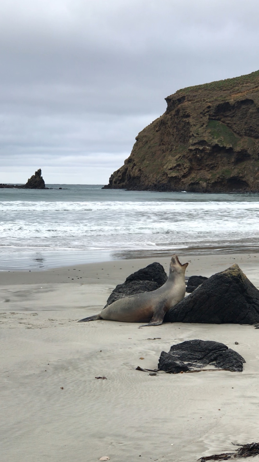
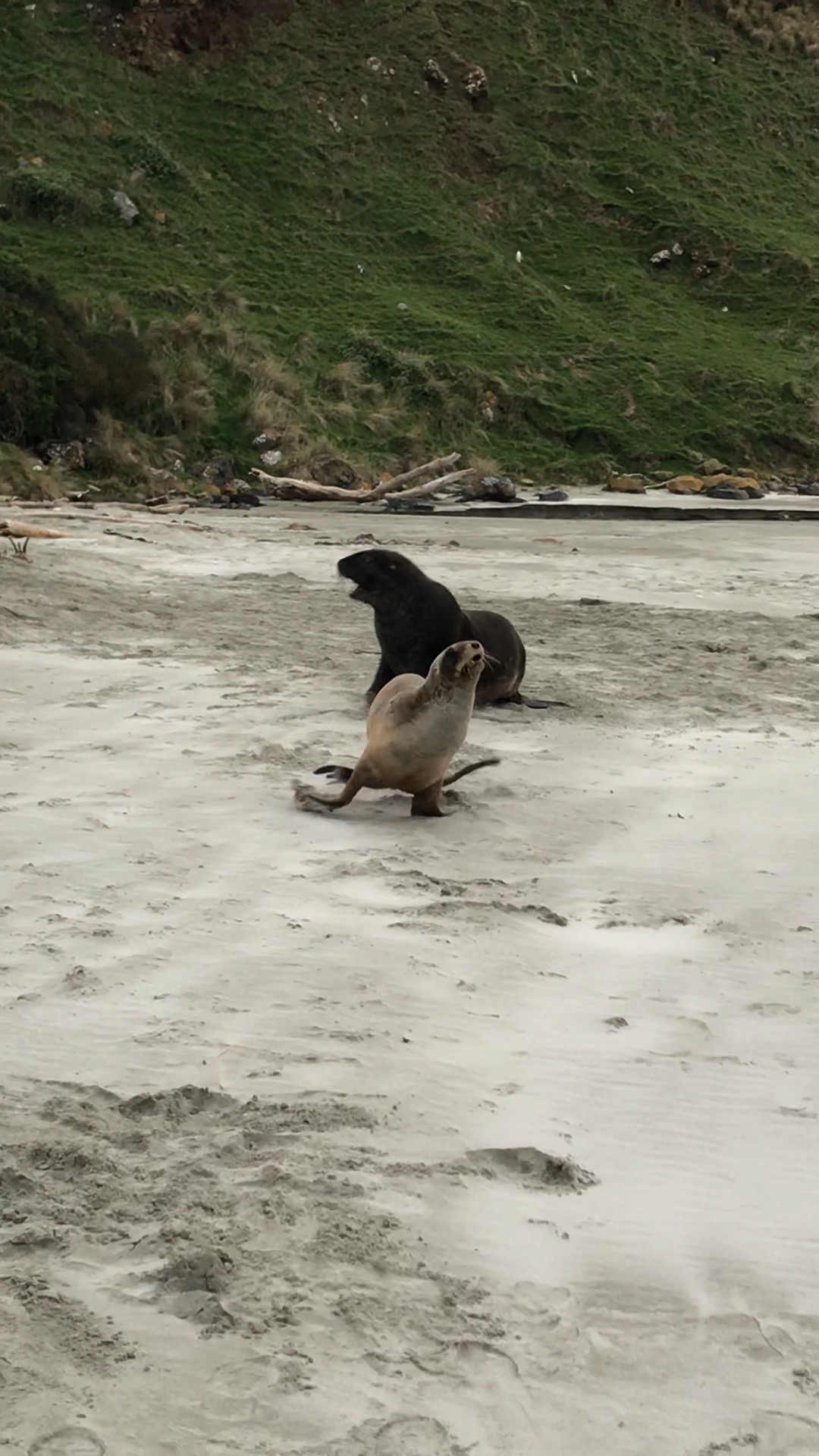
Back in the van on the way to Saunders Point, our guide pointed out more birds, notably, two Little Owls, a Sacred Kingfisher and Pukekos. At the point, we walked down a steep set of steps to the beach to watch New Zealand Fur Seals on the rocks. Young seals were playing in rock pools developing the skills to leave, younger pups were waiting for their mothers to return from foraging to nurse them. We then walked down to a private sanctuary on another beach. The area is leased from the local farmer by Elm Wildlife, who have planted indigenous trees and shrubs above the beach to encourage Yellow-eyed Penguins to seek shelter and nest. The area is separated from the fields and grazing sheep by a wire fence. At one point our guide Shaun had to rescue a newborn lamb that had wandered from its mother and had slipped under the fence, perilously close to sea lions lolling in the sea grass.
We were very near to several Hooker’s Sea Lions, one of the rarest of sea lions, in particular, three females (unusual for this colony) not yet at maturity, so were avoiding the males; and a large male corralling three young male pups, apparently practicing for future mating ventures. We were told that, despite their awkward movements on land, the sea lions could outrun us, if necessary. We kept a respectful distance from the large male!
We had noticed a couple of Yellow-eyed penguins swimming back to shore and making their way up the dunes. From two hides, we were able to watch several waddling up the grassy slopes and also observed a couple preparing for the breeding season. The male was sitting in the nest area and the female was standing guard outside!
Shaun later dropped us off at Etrusco for our 7:00 dinner reservation (no time to change or wipe off our muddy shoes!), where we enjoyed good pizza and Pinot noir in the Savoy Hotel’s lovely Edwardian dining room.
The next morning, we packed up our bikes to take a 6-hour bus to Christchurch. We were lucky to be able to get a taxi of any kind to the bus station as Pink was performing that evening and all vans were booked up. The local newspaper’s banner was printed in pink and some shop windows featured pink displays. The covered rugby stadium where the concert was being held has a capacity of 36,000 people.
We were interested to learn about New Zealand’s relationship with its “first people’s”, the Māori, who make up 15% of the population (Indigenous Canadians = 5% pop; indigenous Australians = 3.3% pop.) 85% of Māori New Zealanders live on the North Island. The Māori language – Te Reo – is an official language of the country, along with English. In 1993, legislation provided for Māori representation in Parliament proportional to their representation in the general population.
The 1840 Treaty of Waitangi, New Zealand’s founding document, has long had a certain stature for Lois. Through that Treaty, the British Crown and Māori people agreed on a set of principles for the establishment of the nation state of New Zealand. While the treaty has assumed the aura of a constitutional document, its legal status is a matter of debate. Unlike in Canada, where Aboriginal and treaty rights are recognized and protected under the Constitution, New Zealand has no formal written Constitution and the the Treaty of Waitangi has not been protected by legislation.
Māori differ from many other indigenous peoples in that they have not lived in New Zealand since “time immemorial”, but rather migrated to the islands between the 9th and the 12thC AD. Māori oral history describes the arrival of ancestors from Hawaiki (the mythical homeland in tropical Polynesia). It wasn’t until the 17th and 18th C that Europeans and others arrived, first explorers (Abel Tasman and James Cook), sealers and whalers, later missionaries and settlers. With French designs on the territory and concerns over lawlessness, England responded to requests from settlers and some Māori chiefs to sign a treaty with the Māori, asserting British sovereignty over the islands and guaranteeing Māori property rights and tribal autonomy. Māori signatories of the Treaty of Waitangi were primarily from the North Island – the South Island was claimed by the British through the doctrine of “discovery”, despite the fact that Māori also inhabited the South Island.
In the decades following the signing, conflict arose over significant differences in the English text and the Māori text, resulting in the New Zealand Wars. Most significantly, under the English version, Māori conveyed “sovereignty” to the British Crown (article 1); but in the Māori version, they conveyed “kāwanatanga” (“governorship”), but retained “tino rangatiratanga” (“chieftainship”, a concept somewhat analogous to self-determination) over their lands, villages and taonga (“treasures”). Thus, many Māori believe that they retained sovereignty and gave away only limited rights of government to the Crown.
During the second half of the 19th century, Māori generally lost control of the land they had owned, some through legitimate sale, but often due to unfair land deals or outright seizure in the aftermath of the New Zealand Wars. In the period following the Wars, the New Zealand government mostly ignored the Treaty and a court case judgement in 1877 declared it to be “a simple nullity”.
In 1975, the Waitangi Tribunal was established to consider claims by Māori against the Crown regarding breaches of principles of the Treaty and to make recommendations to government to remove the prejudice and provide recompense. Since 1985, the tribunal has been able to consider Crown acts and omissions dating back to 1840. This has provided Māori with an important means to have their grievances against the actions of past governments investigated. More than 2000 claims have been lodged with the tribunal. By 2010, legislation had been passed for settlements with a total value of about $950 million. Three early settlements – Commercial Fisheries ($170 million), Waikato-Tainui Raupatu ($170 million) and Ngāi Tahu ($170 million) – and the 2008 Central North Island Forests agreement ($161 million) make up the bulk of this amount. Treaty settlements currently cover more than 60% of the total land area of New Zealand. However, Māori have expressed concern that the value of the settlements is grossly out of proportion to the value of what has been taken from them, amounting only to an estimated one to three per cent of the valued of their total loss. Further, the Government will not consider rights over certain resources, including oil and gas, as the basis of redress for breaches.
A 2011 Report of the UN Special Rapporteur on the rights of indigenous peoples, James Anaya, noted the “extreme disadvantage in the social and economic conditions of Māori people in comparison to the rest of New Zealand society”. While theTreaty settlement process has been instrumental in assisting to provide Māori groups with an economic base for their future economic development, numerous obstacles to Māori economic development remain. The unemployment rate for Māori in 2010 was 14 per cent (compared with 6.6 per cent in New Zealand overall),
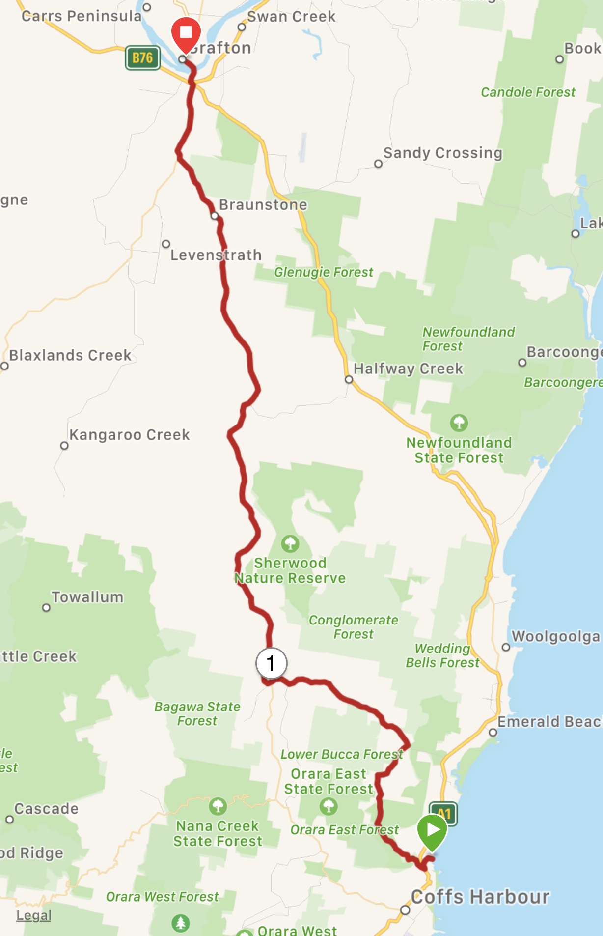
In the morning we began climbing out of Cromwell along Highway 8, the only way we could get through the Cromwell Gorge to reach the Otago Cenral Rail Trail at Clyde. Not far out of Cromwell, we rapidly determined that the road was unsafe for us: a fair amount of traffic including large trucks, two lanes, almost no hard shoulder, a rumble strip, hills and bends and a gusty wind. Plan B was quickly devised. We cycled back down into town to the Grain and Seed Cafe and called the local taxi to ferry us the 26 km to the trailhead.
We were excited to finally be on the “Rail Trail”, which passes through some spectacular and remote areas, only accessible now by foot or bicycle. So, we were disappointed to soon find that the path surface was rougher than described and not at all easy to ride on with our fully-loaded touring bikes. The gradual climb up from Chatto Creek to Omakau was bumpy, tiring and slow, our tires skidding in the sand and gravel, the weather cold and blustery. Stopping for tea at Muddy Creek Cafe, we assessed the feasibility of carrying on for another 100 kms in these conditions, particularly in view of rain forecast for the next day. We decided another Plan B was warranted! We rode up the street to a Shebikeshebikes to inquire about the possibility of a shuttle service or bus that would take us and our bikes to Dunedin. Luckily, Karen was sympathetic and helpful and put us in touch with another company, Bike It Now!, who happened to be running a shuttle between Clyde and Middlemarch the next day. We arranged with them to pick us up at the Muddy Creek Cafe the next afternoon to take us back to Clyde, where we could catch a bus to Dunedin.
We then cycled the last 7 kms along the highway to our lodging in Lauder, the wonderful Muddy Creek Cutting B&B. The B&B is in a characterful 1930’s mud brick farmhouse, with a cozy sitting room with a blazing log fire. Kevin, the co-owner and chef, provides home cooked meals, which, for us was a delectable vegetarian feast made from locally grown produce, washed down with Letts Gully(!) Pinot Noir and ending with enormous slices of homemade black currant pie with whipped cream. Kevin had worked as a volunteer in Sierra Leone in the 80’s and has travelled broadly, so we enjoyed trading stories and chatting with him.
Encouraged by Kevin, we borrowed a couple of their mountain bikes the next morning and carried on the trail for another 7 km across two bridges and two tunnels to get to the top of the Poolburn Gorge. On wide knobbly tires and with suspension, the ride was efficient and pleasurable and we were able to get to see some of the most spectacular scenery of the trail.
We eventually left the B&B, cycling back down the Rail Trail to the cafe in Omakau (we missed those knobbly tires!), where we had lunch and waited for our ride. In Clyde, we stayed in another delightful hostelry before catching the bus to Dunedin the next morning. At the bus stop at an old railway station, we had to remove the front wheels and mudguards of our bikes and wrap the chains, but the bus driver was clearly used to dealing with bicycles and helped us load all our gear onto the bus.
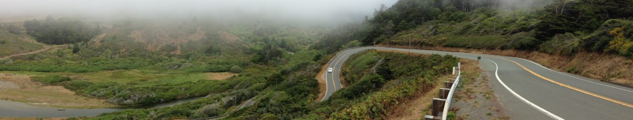
New Zealand’s South Island is considered even more beautiful than the North Island and it’s easy to see why. Rugged fiords, snow-capped peaks, deep gorges, raging rivers and fertile valleys reminded us variously of the BC Coastal Range and Okanagan valley, English moorland and the Yorkshire Dales, all with the addition of thousands of sheep! The temperatures were slightly cooler on the South Island -we were told that snow in September is not uncommon in Queenstown – but as we travelled east, we noticed trees beginning to bud and fruit trees coming into blossom and even the occasional daffodil. We realized that spring has been a constant and delightful feature of our trip since leaving the cherry blossoms of Victoria in May!
New Zealand has a fairly extensive cycle trail system, but as yet the routes are not linked by cycle-friendly roads, nor are they generally paved. We had read that the Otago Rail trail was suitable for all bicycles, so we had planned to cycle that trail, via the Queenstown trail.
Heading out from Queenstown on a clear bright morning, we followed paths around Lake Wakatipu, along the Kawarau River, past the scene of the Pillars of the Kings from Lord of the Rings and then on to the Kawarau Bungy Centre, where the sport started in 1988: the video is not of either of us! The Queenstown trail, which is designated as more suitable for mountain bikes, was a bit slow-going, but manageable, the surface a fine gravel with some rocky sections and many steep, windy inclines and descents. At the end of the trail near Gibbston, we had to ride on Highway 6 through the Kawarau Gorge to Cromwell. The road was narrow at times and the hard shoulder intermittent and covered in treacherous winter grit. Fortunately, the traffic was not as heavy as it might have been. Out of the Gorge, we were pedalling past orchards and vineyards, reminiscent of the Similkameen Valley. The valley is apparently renowned for its winds which we soon discovered as we met a strong northeasterly head-on close to Cromwell. It was chilly and tough going at the end of the day.
We spent the past 17 days on an incredible road trip of New Zealand’s North Island with Maritia, Steve, Jade, Rhys and Emme. Maritia devised a great itinerary, with the help of New Zealand Tourism, which took us across the Coromandel Peninsula to the east coast, through to Rotorua and on to Hawkes Bay and Wellington, then north again past Mount Taranaki to Waitomo and back to Auckland, via Maramata. It was 17 days of wonderful sights and experiences for us all, and much fun with the family.
Highlights:
Mount Eden at sunrise
Ferry and wandering around Devonport
Driving Creek Railway and views of Hauraki Gulf
Cathedral Cove & Hot Water Beach
Te Puia: Cultural centre, crafts institute, geysers
Redwoods Tree Walk
Bike ride in Hawkes Bay
Te Papa Tongarewa – Museum of New Zealand, Wellington
Waitomo Caves
Hobbiton
Auckland Sky Tower
We have now flown to Queenstown on the South Island to see a bit more of New Zealand over the next couple of weeks, before finally heading home. We will be back on our bikes tomorrow to begin cycling from Queenstown to Dunedin, following the Queenstown Trail and Otago Rail Trail.
We are on the traditional territory of the Yuggera People
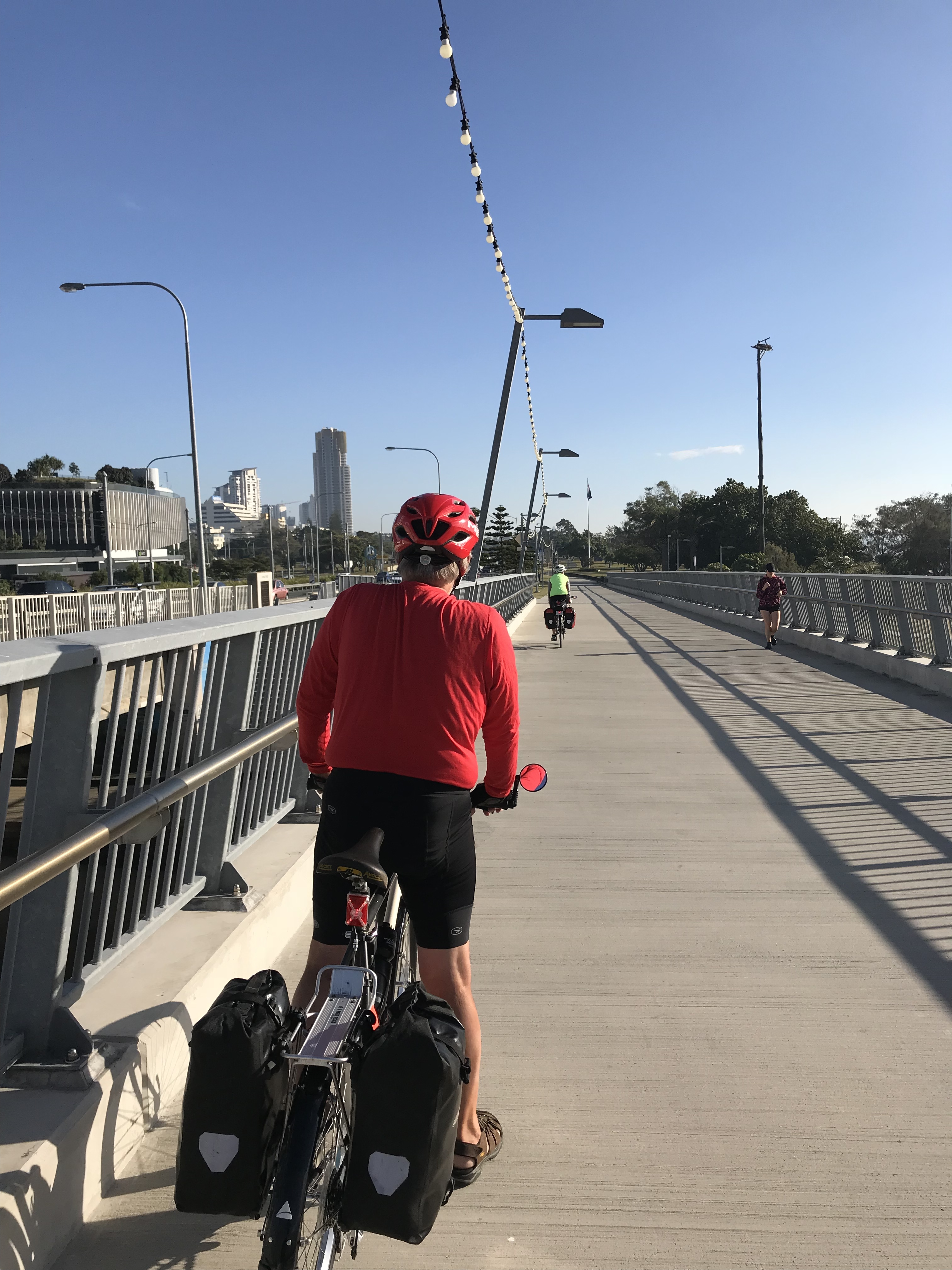
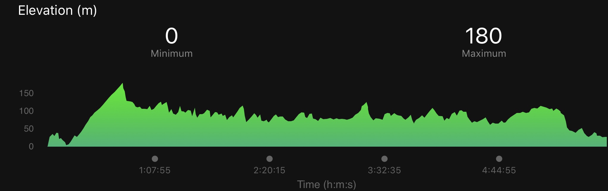
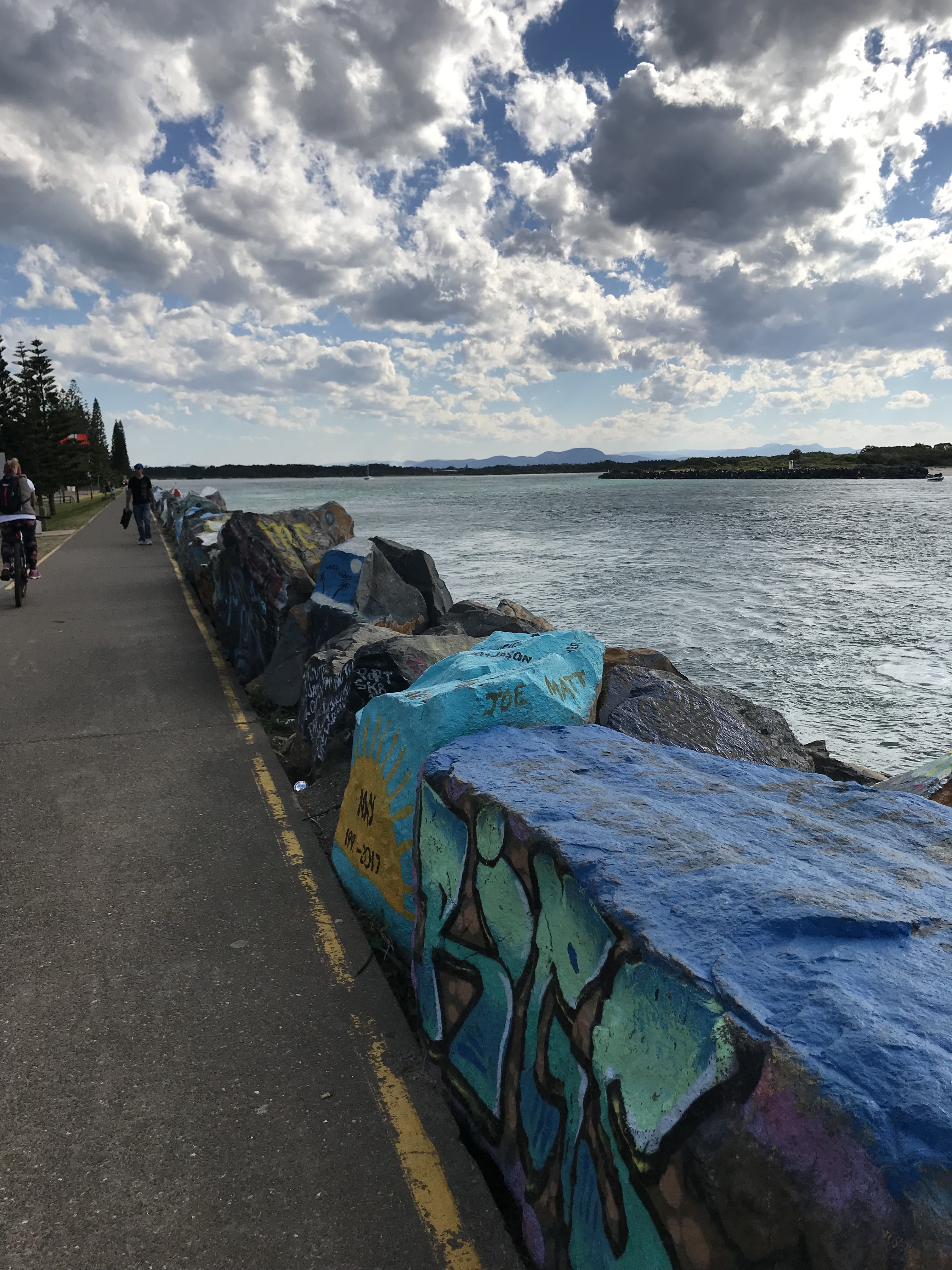
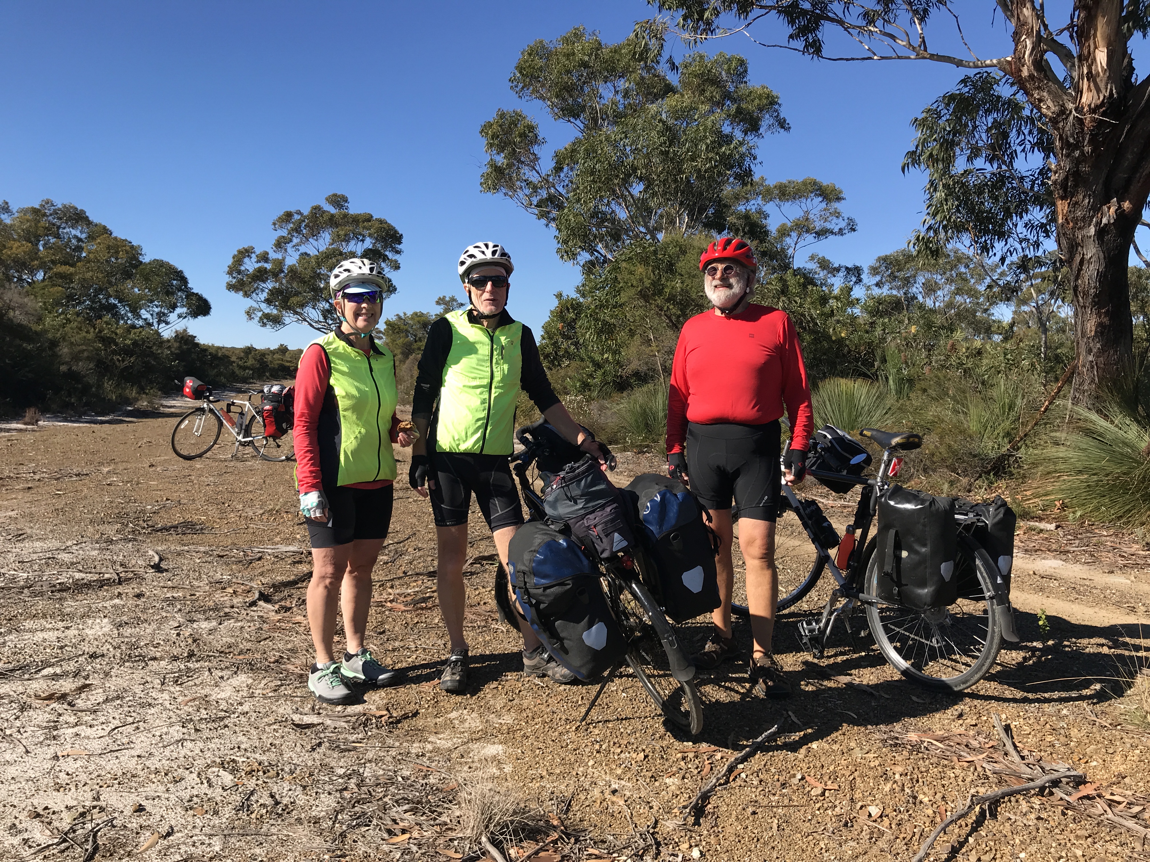
It was a relaxed final day, with no highway cycling, the end of our 1155 km bike trip in Australia, nearly 800 kms for Wayne.
The ride began with a stop at Shorties Espresso, just down the road from the hotel. To avoid the highway, we followed the CycleWayz route from there, which took us up to the Daisy Hill Conservation Area, with a view of the Logan Valley, eventually winding our way down on to Miles Platting Road and back on the V1 Cycleway. On the path, we met David, whose bike was set up to carry three of his grandchildren, with modifications planned to accommodate two more! He showed us a photo of when he transported a washing machine on his bike…..
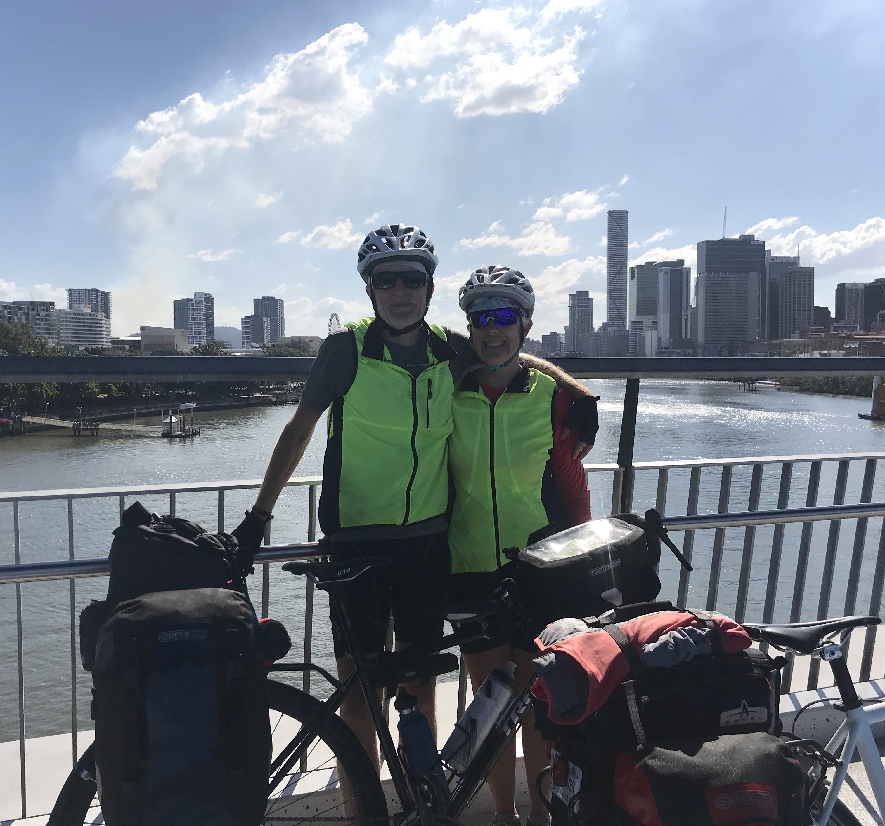
The V1 into the city was dedicated cycle path, large sections of which are a three metre-wide path adjacent to the Pacific motorway, a little noisy perhaps, but a joy to cycle on. Arriving at South Bank, we cycled across the uniquely-designed pedestrian/cyclist Goodwill Bridge, stopping to take some celebratory photos, and on to our hotel on the Queen Street mall.
The V1
David
Brisbane River
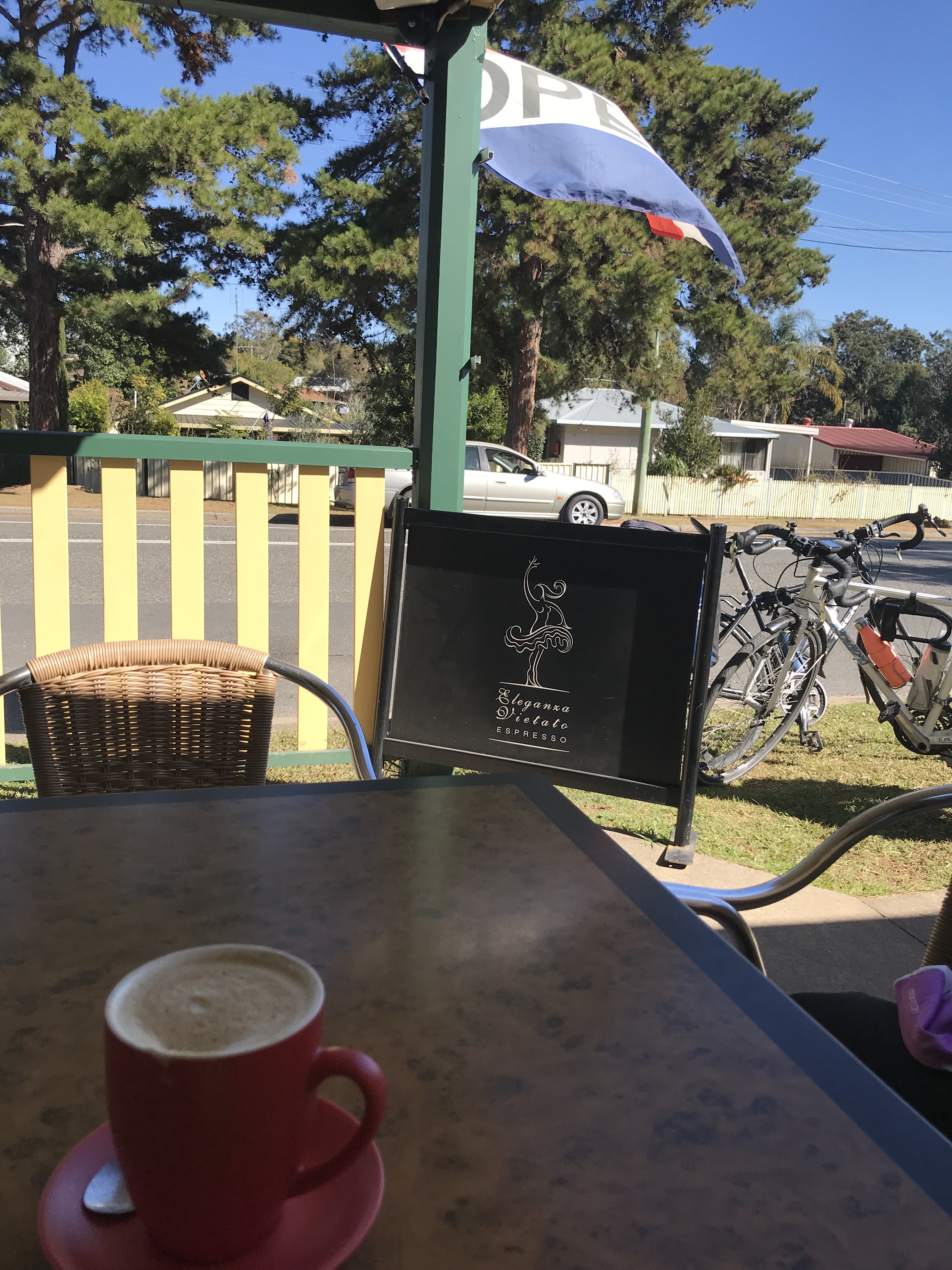
Our time in Brisbane was too short, but fun. We took in some live jazz at the Do-Bop Jazz Bar; had coffee and a mini-tour of South Bank, the bridges and the Botanical Gardens with our friend Sharon’s sister, Allison, and her husband, Tony; visited the Museum of Modern Art; and went out for a Japanese meal and interesting evening with Di and John, friends of Isabel.
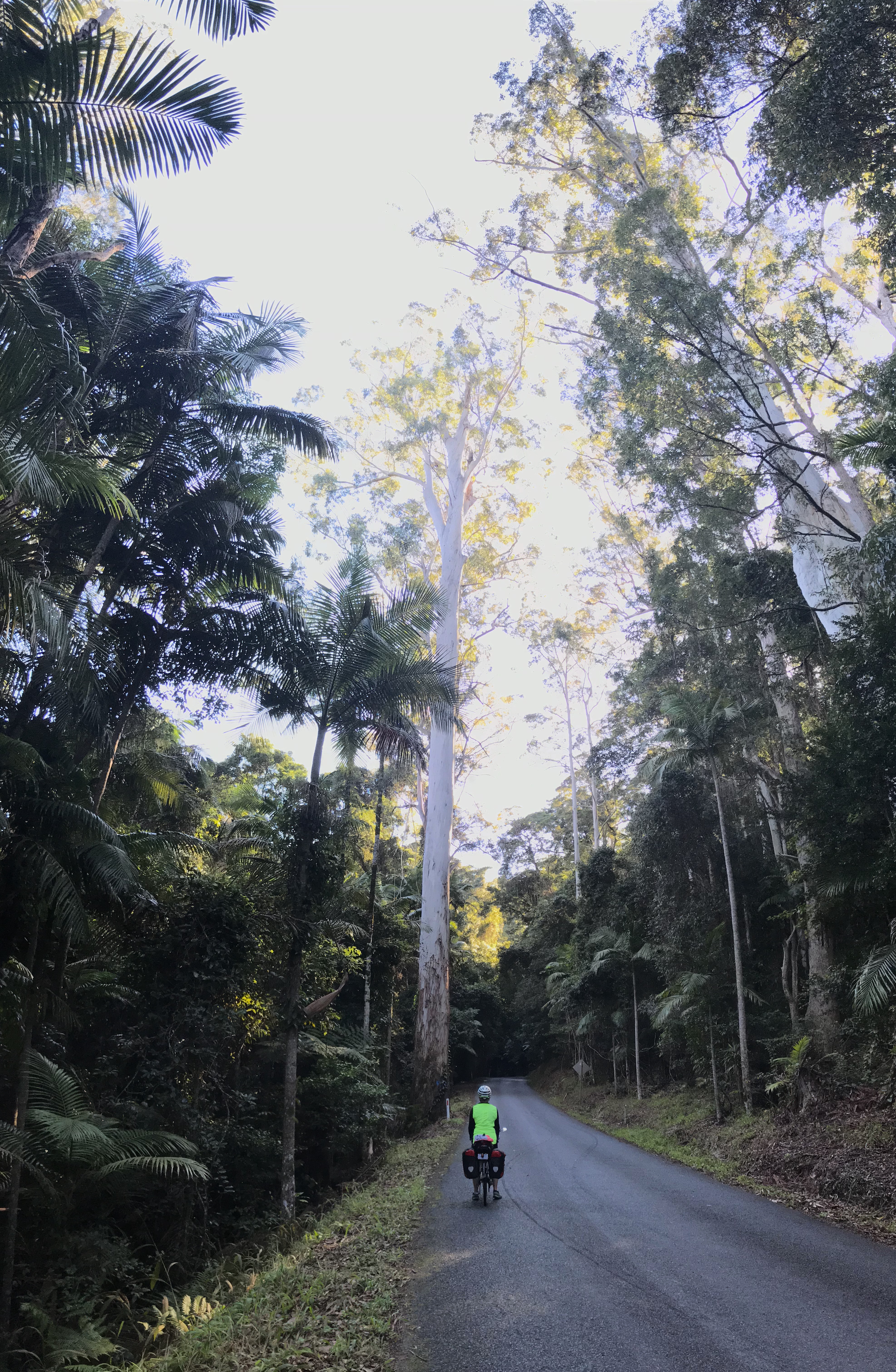
With our bikes packed up once again, we left Brisbane for Auckland yesterday. We have so appreciated this brief introduction to Australia, its extremely friendly and welcoming people, excellent food and wines, endless beaches, towering eucalyptus trees, multitude of national parks, the allure of the outback, perfect cycling weather and an inexhaustible supply of good espresso. Paul’s list of Australian birds reached 73.
We are taking some time off in New Zealand to vacation with our Victoria family, who are meeting us here tomorrow. We expect to be back blogging about the final weeks of our trip after August 24.
Coffee notes: Black Lab Coffee – good 8.75/ 10 espresso from Locale. Their No 143 is a blend from Tanzania, Colombia and India.
We are on the traditional territory of the Bundjalung Nation
We are staying in City of Logan. “The acknowledgement and acceptance that Logan has a vast and rich indigenous and cultural history, enhances our commitment to reconciliation and gives us a deeper understanding of our past“ (City website).
As we three were leaving Crema Espresso, we were cheered on by Jeff Downes. Also an avid (boomer) cyclist, he was eager to mention us on Facebook. We will be looking at his website.
The route turned inland through Southport and the waterways of the Goldcoast hinterland, past subdivisions with moorings, backing onto the water. Then, we were into small towns and industrial estates close to the M3 Motorway. Near Beenleigh, we could smell the rum distillery, a byproduct of the sugar cane industry. The town square in Beenleigh was a quiet respite, where we ate pastries from the mall bakery beside the fountain in front of the courthouse.
We are now cycling on the Veloway 1 (V1 Cycleway), which follows the M3 and M1 motorways between Brisbane and the Gold Coast. Today was a combination of dedicated bike paths and in-road bike lanes, but we expect more off-road cycling as we get closer to Brisbane. We were pleased to find that every roundabout intersection on this route has a paved cycle path around the perimeter, making it safer and easier to get around (ie, just crossing each exit, rather than cycling in the roundabout, something we would rather avoid.)The one exception was the large, very fast roundabout accessing the motorway (M1) at Beenleigh. There appeared to be a bike path between exits for cyclists going north-south, but not the other way. Tomorrow will be our final day cycling in Australia!
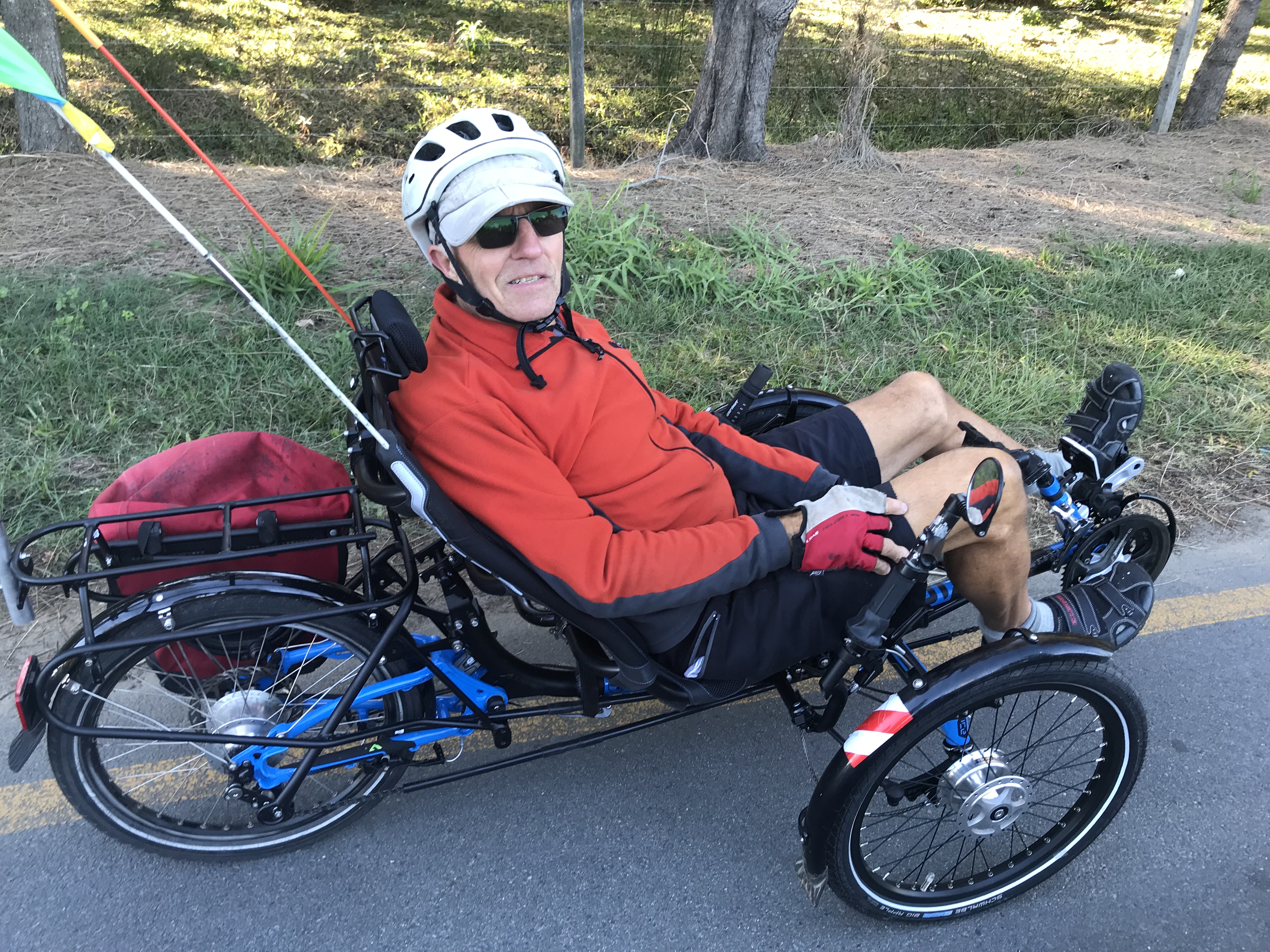
On Wednesday’s blog, we forgot to mention meeting Barry, another cyclist keen to chat about touring. Barry cycles on a recumbent bike which he swears by.
We are on the traditional territory of the Yugambeth People of the Bundjalung Nation
We followed the Tweed Cycle Way alongside and across the Tweed River, which took us under and then up and over the Pacific Highway. From the path, we could see Wollumbin (previously Mount Warning), an old volcanic plug.
CycleWayz
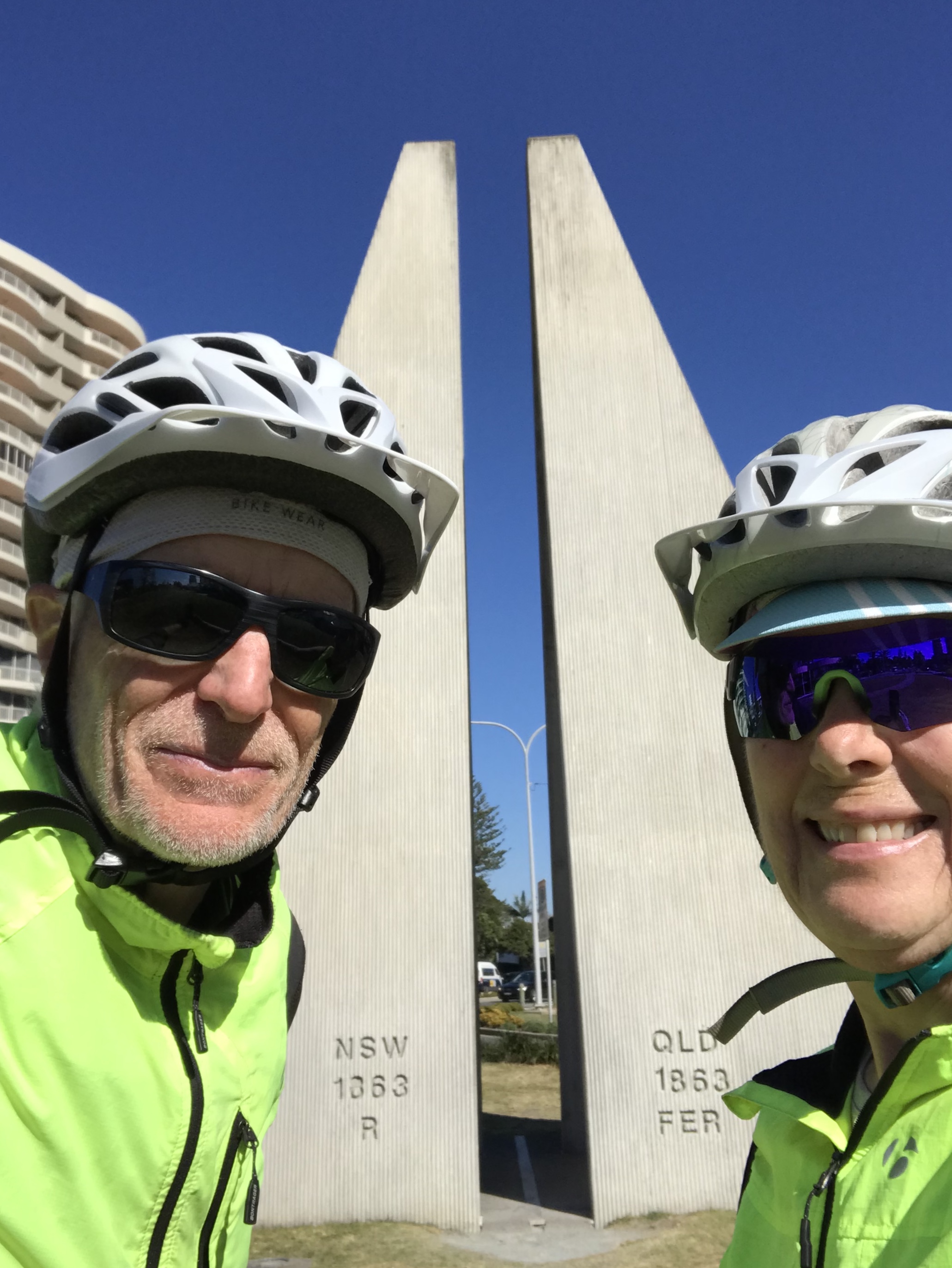
In Tweed Heads, we turned off on Dry Dock Rd for breakfast at Next Door Espresso. Sitting outside in the sun, we enjoyed very good Byron Moonshine espresso (8.75/ 10) and scrambled eggs on sourdough (with an added side of avocado, of course). Further along, we stopped at a small park on the water for another view of Wollumbin, then turned down Boundary Road, the boundary line between the states of New South Wales and Queensland. A quick selfie to mark the completion of our 1000+ ride through NSW, followed by a very short, but steep, climb and we were at Point Danger (named by Capt. Cook) and Snapper Rocks. This area is famous for its wave and consistent surf, but there were few surfers in the water today.
CycleWayz
As we passed inland to Burleigh Head National Park, we came across the Jellurgal Cultural Centre, “Jellurgal” being the indigenous name for the headland. We could not take advantage of a guided tour of the Park, but walked through the cultural exhibit of the life and times of the Yugambeh People.The Yugambeth, who comprise a number of tribes/ clans which are part of the Bundjalung Nation, are the traditional custodians of the land located in south-east Queensland and north-east New South Wales. The most telling phrase on the wall of the centre was “We are still here”.
The remainder of the ride to Main Beach was fairly flat on bike/ pedestrian paths, quiet streets or separated bike lanes. After so many awe-inspiring vistas of endless unspoilt beaches on this trip, we were a bit disconcerted to see high rises further up the coast! As we approached Surfers Paradise, the coastal path and beaches were busier, with cyclists, pedestrians, surfers and sunbathers. A beach market was not yet open much to Lois’ disappointment. We could imagine what this coast must be like in the height of summer, but just now it is relatively quiet and low key.
Meeting up with Wayne again, the three of us went out for tapas (and Tiramisu!) at Bistro Chico. We are taking a day off to enjoy some beach time and rest in our 15th floor holiday apartment facing Main Beach, before our final two days into Brisbane.
We are on the traditional territory of the Bundjalung Nation
Hastings Point
We can highly recommend the Brunswick Heads Motel. It is bright, stylish and contemporary, and serves an amazing continental breakfast featuring local produce with fresh fruit, yoghurt, meusli, sourdough and fruit breads, avocado smash, croissant sandwiches and barista coffee. Our server, Georgia, was from Vancouver- we recognized her accent! (Her parents have also just moved to Victoria.)
As we were having a second (Campos) espresso at Torakina Café we received a text from Wayne to say that he could not get his bike re-assembled (after having to pack it up for the train) until Wednesday morning. He will now take a bus and meet us in Main Beach.
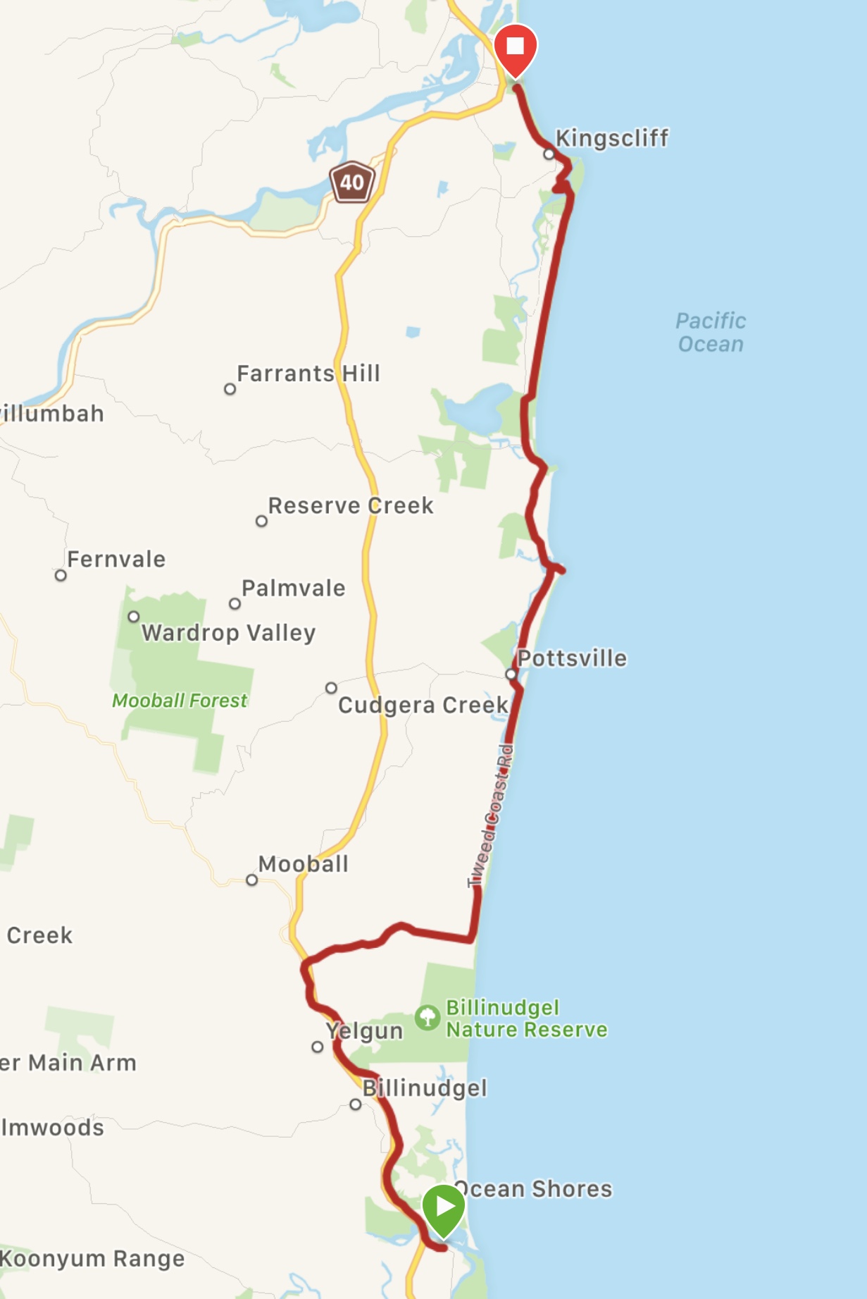
We had quite a hilly start, but the route flattened out after we turned off the Old Pacific Highway onto the Tweed Coast Wooyung Road, through Wooyung Nature Reserve and, from Pottsville, on the Tweed Cycle Way. At the Cornerstone Espresso Bar in Pottsville, we shared a lunch of good Tuscan bread salad. The cycle path, which took us all the way to Kingscliff (apart from a detour close to the end), was on a good track through coastal woodland, close enough to the beach to hear the surf. Stopping at a fruit stand to buy apples and locally dried fruit, we were advised to cycle up to Hastings Point for the view and whale-spotting. This we did, and were rewarded with stunning views of beaches to the north and south and sightings of migrating humpbacks. Cycling in to Kingscliff, we decided to call it a day. After checking into our motel, we filled our David’s Tea thermos with Darjeeling and went down to sit on the beach.
We are on the traditional territory of the Bundjalung People
We were pleased to find a websiteof the Arawkal People of Byron Bay who have lived in the area for at least 22,000 years. Since 2001 the Arakwal people have entered into three Indigenous Land Use Agreements with the New South Wales Government recognising our rights as Traditional Owners to lands and waters in and around Byron Bay within this area.
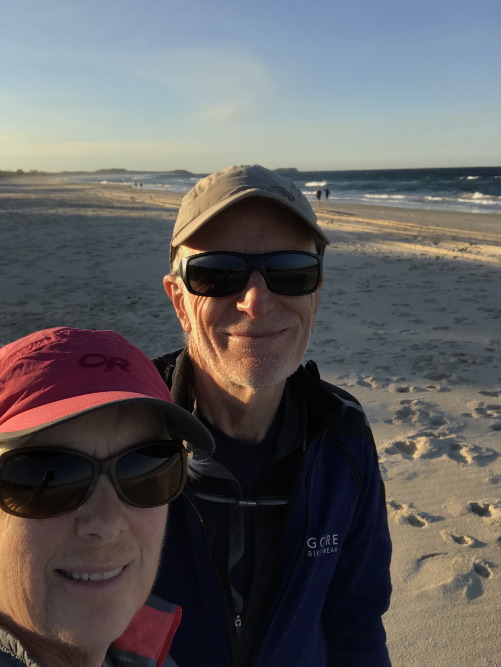
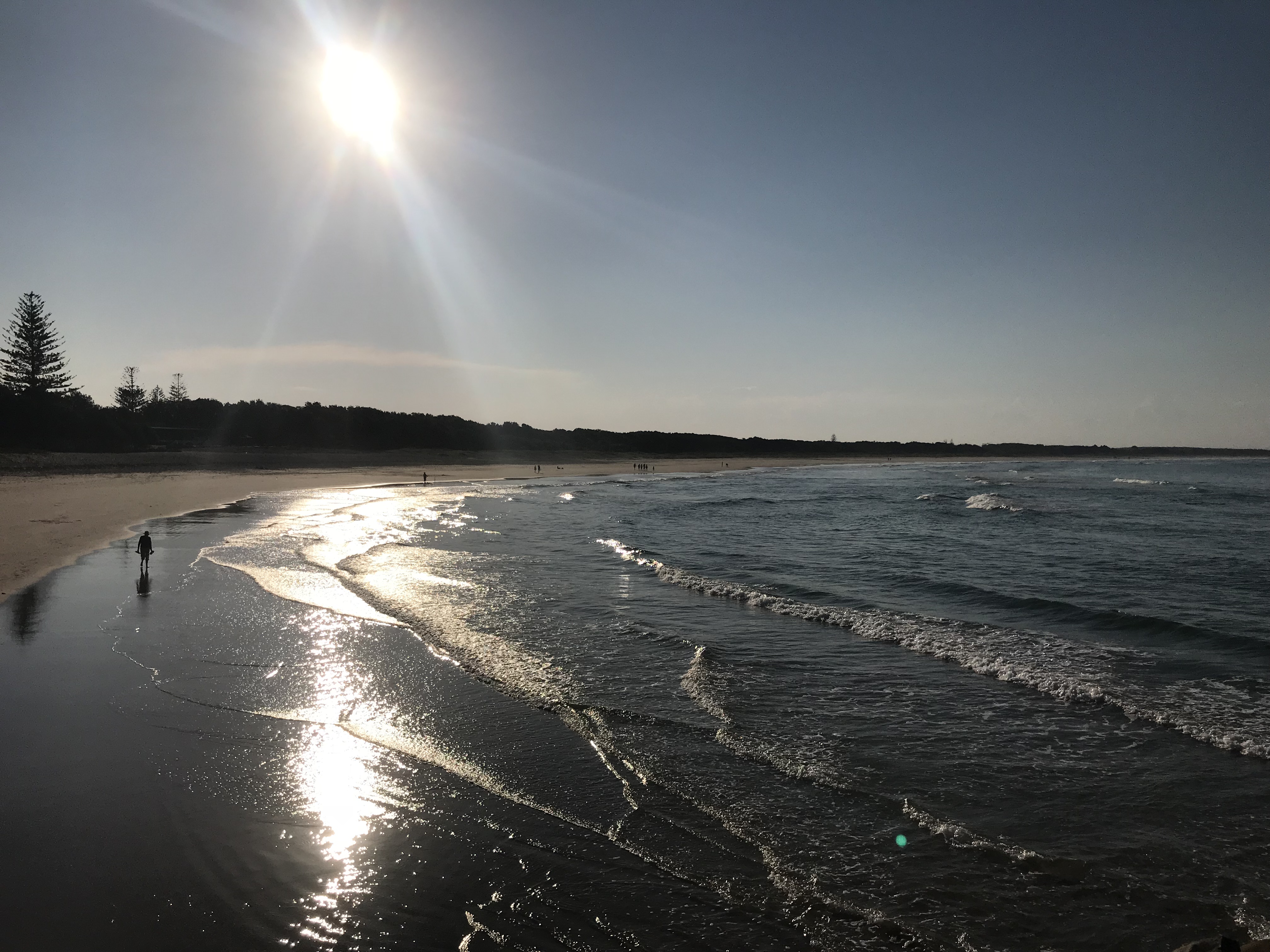
Lennox Head sunrise
The good and not so good continue. The Campos espresso at Quattro was predictably awesome, particularly when sipped looking out on Seven Mile Beach. Lennox Head is a National Surfing Reserve, with its right-hand point-break one of Australia’s most famous waves. We did not see any surfers out this morning, or identify the direction of the wave break! But, we did enjoy the sunrise over the water, still a novelty!
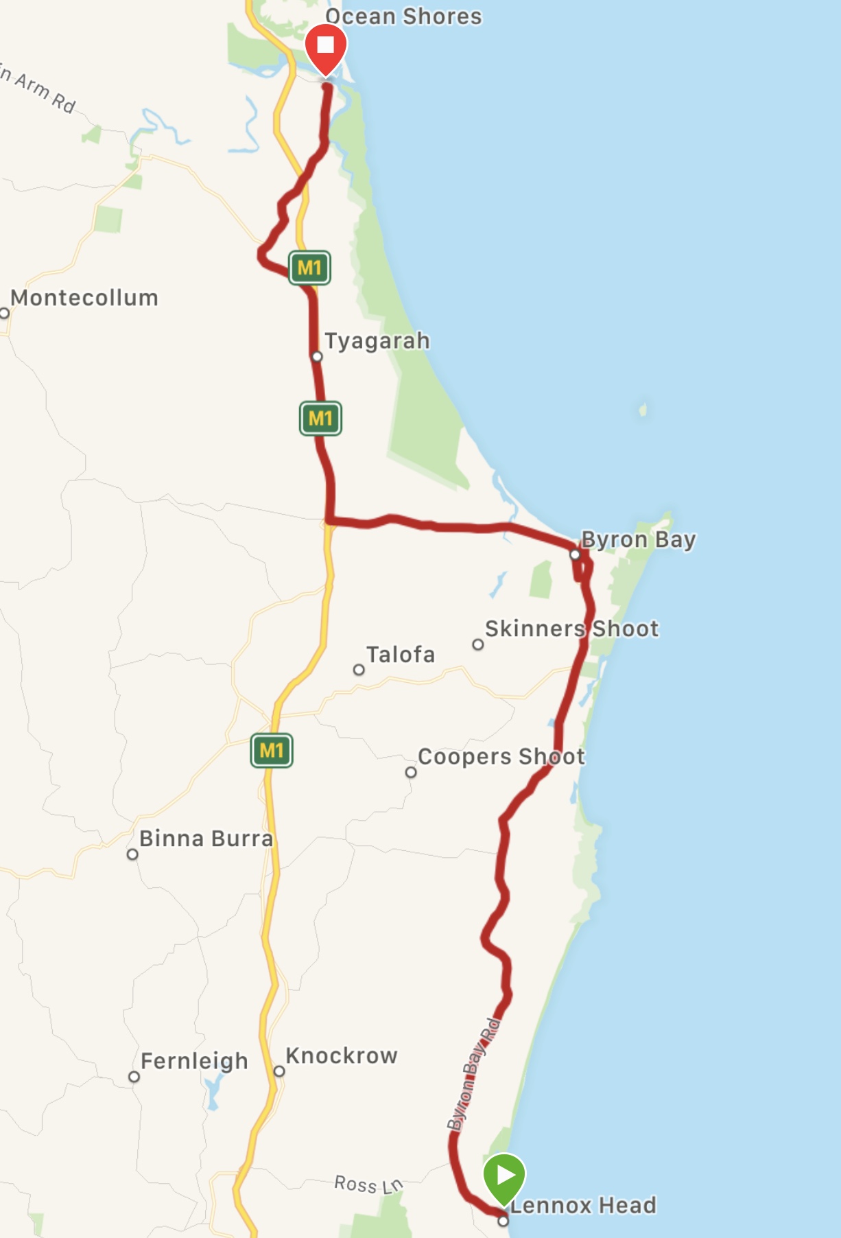
After leaving the town, we had to cross over and on to the busy Byron Bay Road. Soon after, much of the traffic turned off towards the Pacific Highway. Road works meant that the traffic passed us in waves, giving us periods of calm to enjoy the ride through rain forest scrub. In Byron Bay, we stopped to pick up take out macchiatos from Espressohead, which we took down to the beach to have while FaceTiming with the Victoria family.
Just as we were chatting to a man who was interested in our cycling, we received a text from Wayne to say that he was sitting in a café down the street, having taken the bus from Mullumbimby! We met up and planned for our reunion on the road tomorrow.
From Byron Bay to Brunswick Head, for about six kms we had no option but to take the Pacific Highway (M1) with a variable hard shoulder and multiple exits, until we turned off on the relatively quiet Gulgan road.
We are on the traditional territory of the Bundjalung People
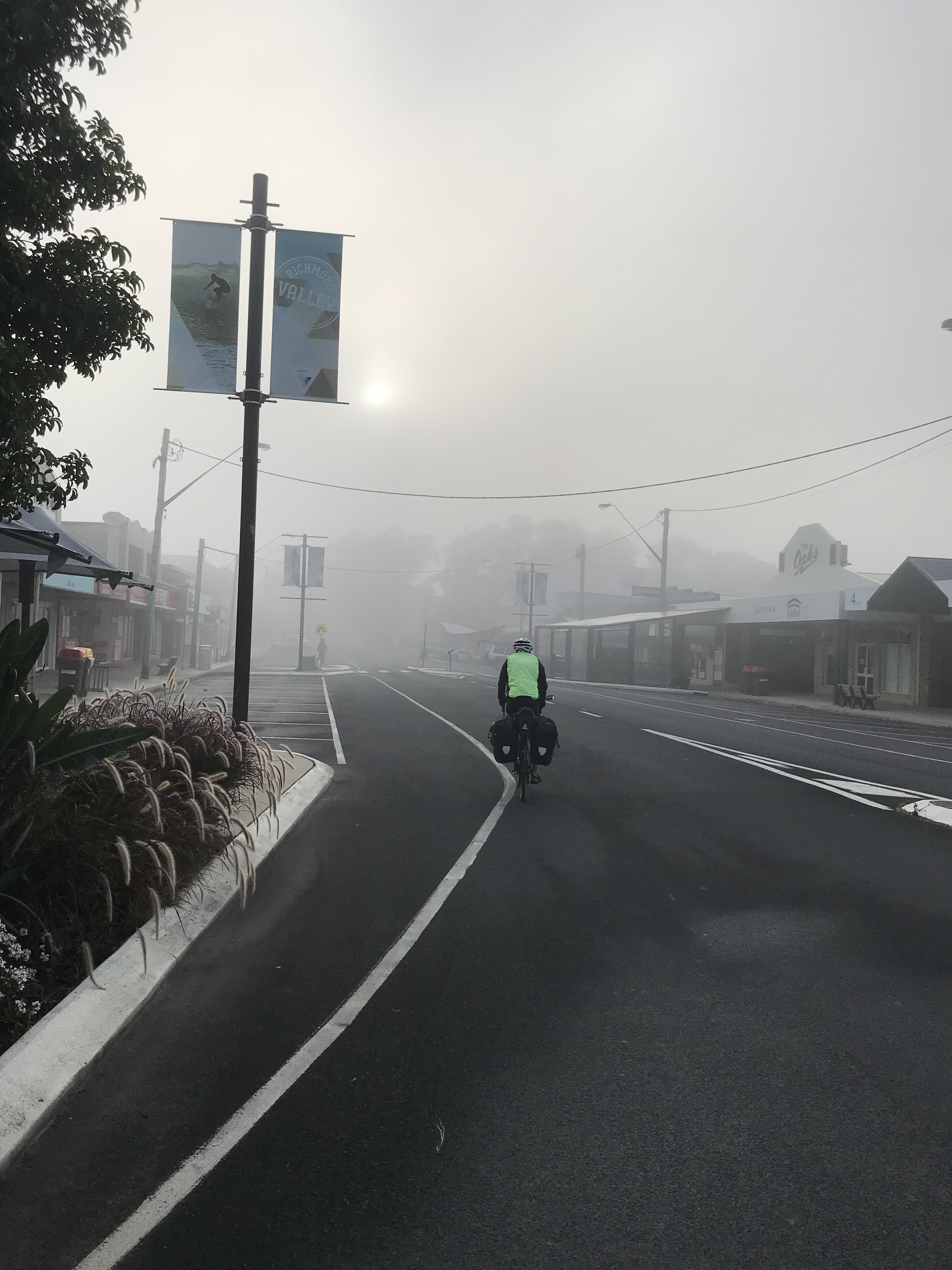
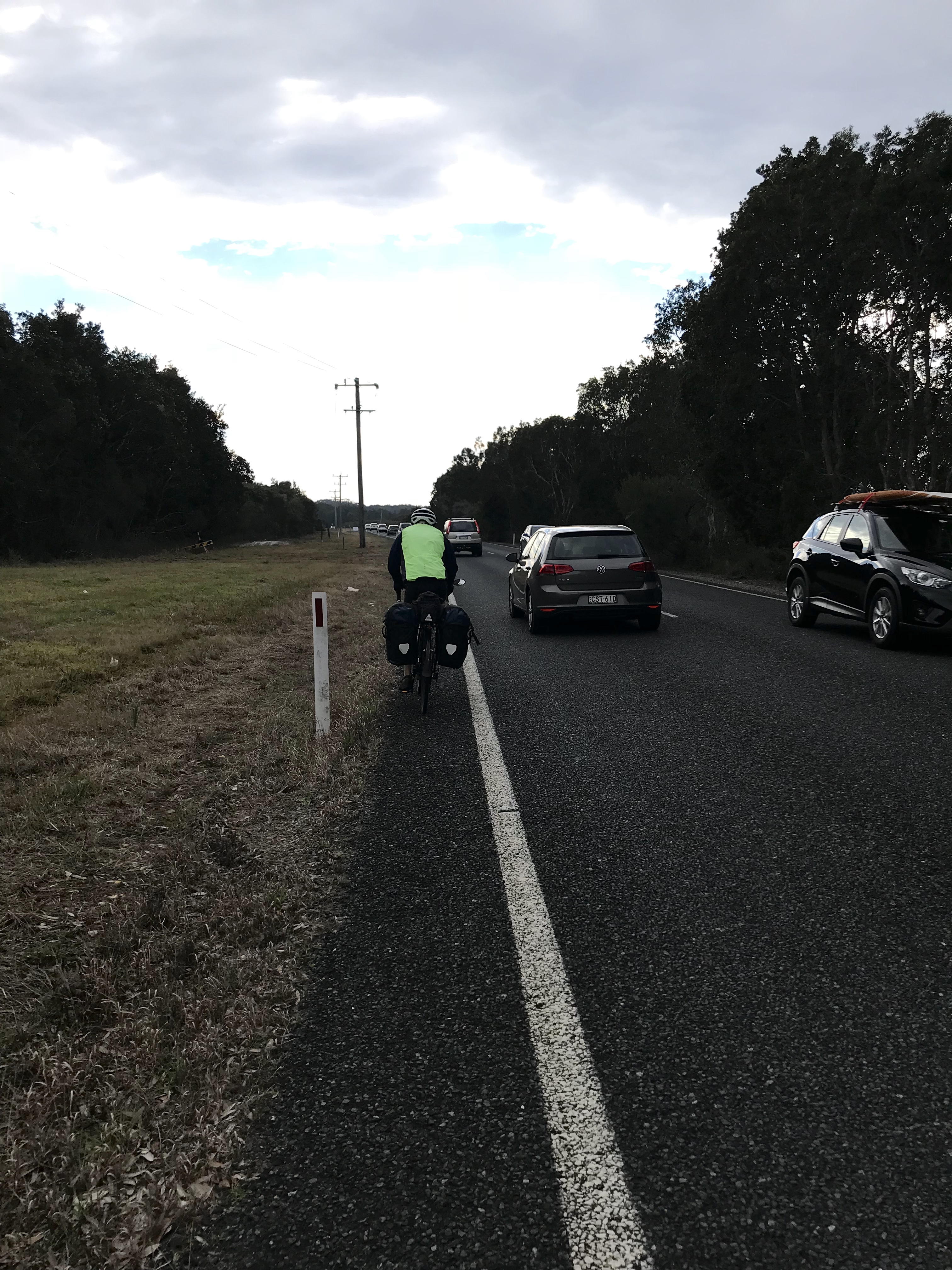
Today, for the first time, we are feeling discouraged. Perhaps, it’s just time to wrap up this long-term adventure. We are definitely still loving the cycling, seeing the countries, meeting people, eating great food, learning. But, we are becoming increasingly less tolerant of cycling beside fast moving vehicles, especially on highways or busy narrow roads with no hard shoulder. The CycleWayz app we have been using in Australia has been good in directing us off the highway, where possible. But, the route also takes us away from built up areas, where accommodation is more available, which for “posh” cyclists (as we were referred to the other day!), who aren’t carrying camping gear, is a challenge. The only alternative is cycling on busy roads. Where cycle paths exist, they do not usually extend beyond the outskirts of a town. An added difficulty in Australia, or at least in New South Wales, is the relative absence of pedestrian crossings and traffic lights across main roads.
When we left Johnny’s (Nats Coffee – Byron Bay 8.5/ 10) – a not for profit operated by the Mid Richmond Neighbourhood Centre, it was still misty, unusual according to our barrista. We thought we could smell smoke in the air and were told that burning of sugar cane happens at this time of year. We had a quick look at the beach on the way out of town and then rode through Broadwater National Park, with coastal banksia and grass trees, the lingering mist prompting us to put on our headlights. Signs warned of kangaroos on the road, but none were around. There were lots of birds.
At Broadwater, after passing a large sugar refinery belting out smoke that smelled vaguely sweet and vegetal, we hit the Pacific Highway. Fortified with a second coffee at Our Daily Bread Cafe (in the old church !), we tackled a few kilometres of two lanes, lots of traffic and not much of a shoulder, then turned off on River Drive along the Richmond River. Cycling under the highway bridge, we noticed a sign indicating that during bridge renovations, an osprey nest had been moved from one of the bridge towers to a huge pole erected for the purpose. The nest appeared to be empty, although an osprey was perched nearby on another power pole. Just afterwards, we were both dive-bombed a number of times by a magpie. Lois noticed it attacking Paul and then it came after her! We could hear the sound of its wings as it swooped down from above and behind. A couple of times we each heard a “clack” on our helmets from its claws or beak! Later, we read that such attacks are not uncommon, especially against cyclists! Quite an unnerving experience. Thank goodness for our helmets!
The rest of our ride along the Richmond river to the Burns Point Ferry was uneventful! While waiting for the ferry, we chatted with a pleasant couple in their early seventies, who had been out for a short Sunday bike ride from East Ballina. Just in town, we stopped to photograph a giant prawn made of concrete and fibreglass. In March 2018, Google Maps’ facial recognition software apparently blurred out the facial area of the Prawn! As we were having lunch (Thai king prawn salad ?), a young couple with their eight year-old twin daughters approached us, curious to know about our trip. They are mountain bikers themselves and their girls are also getting involved.
The 2-lane Coastal Road to Lennox Head was extremely busy, with no shoulder. We had thought we would be safe on a tourist road on a Sunday in low season, but another cyclist told us that on Sundays everyone is out on the roads racing from one surfing beach to another! Taking a break from the traffic at Pat Moreton lookout, we caught sight of the spray of humpbacks in the bay. This, plus FaceTime with our grandchildren in Paris helped to restore our mood.
We are on the traditional territory of the Bundjalung People
We set the alarm for 05:30 so that we could catch part of the total lunar eclipse, the second we have seen in six months. The first, also a « blood moon », we viewed in Goa on January 27.
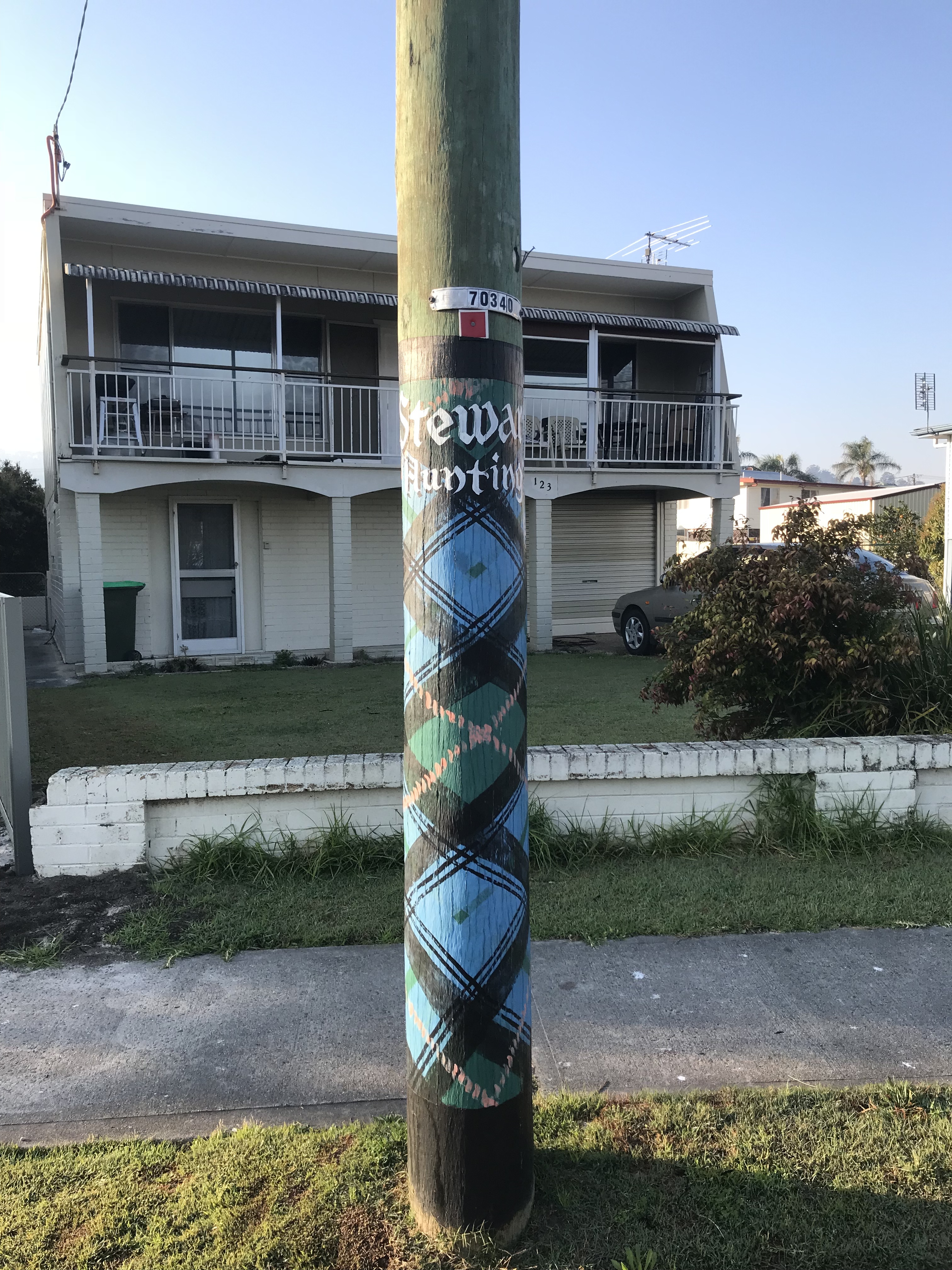
Cycling to the River Cafe for our morning jolts, we admired the tartan-painted power poles, celebrating Maclean’s Scottish settler heritage. With the downturn of the economy in the 90’s, it was decided to market the town’s history beyond an annual highland gathering. When the Olympic torch was coming through MacLean before the Sydney Games in 2000, hydro poles were painted with tartans. Afterwards, more and more people wanted to commemorate the history of their families and now there are 240 adorned poles lining the streets. We found MacIntyre (Helen) and Stewart (Steve) but not Leslie, Fraser or Murray.
A few kms along the Clarence river we passed Ulugundahl Island which was a mission reserve. During the 1800s, the government rounded up the aboriginal people and put them on the island to live under «white management ».
Our ride this morning was on the Pacific Highway (A1) but first we had to cross the Clarence river on the old bridge at Harwood -the new bridge is still being constructed. There is a pedestrian path on one side of the bridge, but with all the road work, there was no cycle path leading to it. We had to heave our panniers and bikes over a guard rail to get onto the walkway. At the far end, it required going along a grassy track to get back on the road! It was then a heads down, quick and dirty pedal along the A1 for 46 km to Woodburn. Despite being a Saturday, the traffic was heavy and constant, with many large trucks and construction work going on practically the whole way. The hard shoulder varied from wide to almost nothing. We did get some relief at two rest stops (one at New Italy).
We had planned to stay in Woodburn, but finding the town and our intended accommodation uninspiring after the stress of the highway, we diverged from the route and headed to the coast at Evans Head, along a mercifully peaceful road lined with sugar cane fields. After checking into our motel, we bought ice cream (passion fruit) and a vanilla milkshake and sat at the end of the breakwater looking out over Airforce Beach in the afternoon sun.
We are on the traditional territory of the Bundjalung People
The Bundajalung are a large Aboriginal nation, a federation of a number of groups of clans which occupy the land from Grafton on the Clarence River of northern New South Wales north to southern Queensland, and down around the other side of the Great Dividing Range and back to Grafton.
Six Aboriginal communities are represented within the local government area of Clarence Valley at Baryulgil, Malabugilmah, Grafton, South Grafton, Maclean and Yamba. The 2011 Census reported 2,846 Aboriginal and Torres Strait Islander people in the Clarence Valley. Of these, 1,406 (or 49.4%) were male and 1,440 (50.6%) were female; the median age was 20 years.
Like many Australian towns we have cycled through, Grafton has a number of well preserved buildings, which give it an old town vibe, together with wide streets lined with palm trees and diagonal parking. (The diagonal parking is tricky for passing cyclists!) Grafton is famous for the annual Jacaranda festival, held in late October/early November, when the town is ablaze in purple blossoms. We had thought that Purple Haze cafe, which served us good Vivo espresso this morning, was a reference to Jimi Hendrix, but on reflection, it is probably related to Jacarandas! (or both).
We did not follow the CycleWayz route today, which would have taken us on a 100km ride to Casino, with an unpaved section – a risky distance when the hours of daylight are still limited. We had assumed that the alternative was the Pacific Highway, but discovered another paved road, Tourist Drive #22 to Lawrence and MacLean, which follows the Clarence River floodplain. It was an easy and pleasant ride on a quiet country road through cattle and dairy farmland, the road alongside the river at times.
Before Lawrence, we began to be surrounded by sugar cane plantations. We find that sugar is big business in Australia and most raw cane sugar is exported. The Lawrence cable ferry took us across the Clarence River a few kilometres from the town of MacLean. It was a warm 22oC this afternoon, but increasingly cloudy for the first time since Sydney. We have become so accustomed to blue sky cycling in Australia that our rain gear has been pushed to the bottom of our panniers.
We are on the traditional territory of the Bundjalung People
It’s just two of us cycling for the next few days. Wayne is taking a break and will meet up with us in Lismore on Sunday.
We made espressos with our Wacaco and walked our bikes up the steep hill from our motel on the beach below the Pacific Highway. The cycle route we planned to join went off on Bruxner Park Rd. directly across the four lanes of traffic and two turning lanes, but there was no traffic light or safe way to get across the highway. With no breaks in the traffic, we eventually decided to cycle 500m down the highway to the exit for the Pacific Bay Resort to see if we could arrange a taxi to take us across the highway. There, Lois discovered that there was a tunnel under the highway just behind the resort. It was apparently there to connect to a golf course that was never built. Who knew! Through the tunnel, we walked our bikes across a paddock, clambered over a locked gate and we were back on our route, nearly an hour after leaving our motel just a kilometre away!
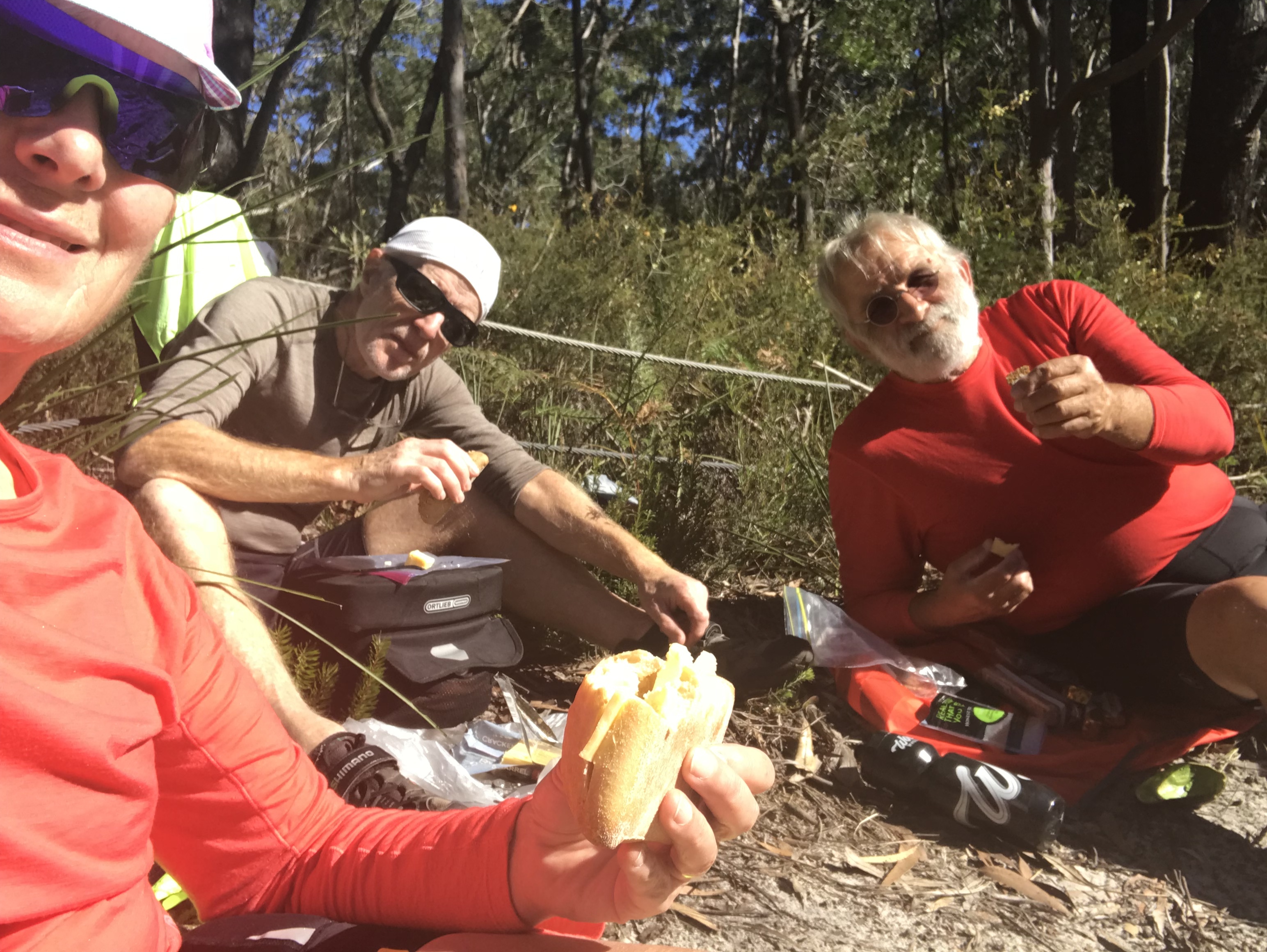
We then had a continual 40-minute climb high above the highway, giving us great views of the sea and the banana plantations, for which Coffs is well known. At the top, we cycled through the dense and cool old growth Orora State (rain) forest, mesmerized by the enormous trees. Soon, we were out in ranch country which continued the rest of the day. This region was famous in the past for timber, especially red cedar. Near Nana Glen (Lois liked the name!) where we stopped for a welcome coffee, the pastures were interspersed with large netted plantations, likely blueberries. The road was narrow and undulating, but not too busy, allowing us a rare chance to put on our music. We ate our usual cheese, crackers and apples sitting beside the road. A young couple passed us cycling in the opposite direction. They have been cycling from Britain for the past 18 months and were on their way to his home in Melbourne. She was from southern Italy.
Stopping later to get tea at a gas station, we asked if there was a toilet. “Not with water” was the answer. It had not rained for 12 weeks and they were in a drought and waiting for a tanker to deliver water. We got to our motel just before sunset after crossing the bridge (1932) over the Clarence River, on the walking/bike path attached to the bridge next to the railway line underneath the roadway.
Jane Gow is the Coordinator of the Coffs Harbour Parkinson Support Group, one of 70 such NGOs in New South Wales that provide information, counselling services and training for health professionals, raise awareness, and fund research grants to find a cure. She kindly agreed to meet with us to discuss her work and PD in NSW. Over coffee in Coffs Central shopping mall, we had a very interesting and informative discussion with this lovely and dedicated lady, grandmother to four. Jane became involved in PD support after her husband was diagnosed in his 60’s. He is now 74. After they retired, they moved to Coffs Harbour from Sydney to enjoy the warmer climate, but are still dependent on the medical system in Sydney. There is no neurologist in Coffs Harbour, a community of 60,000, although one flies in from Newcastle.
The Coffs Harbour Support Group has grown from a membership of around 30, when Jane started the group, to its present size of 126 families. This includes a few spouses of persons with PD, who have continued an association with the group after losing their partners to PD. The group brings in guest speakers, hosts special discussion meetings, maintains a newsletter and holds regular social events. It relies on volunteers and fundraising to carry out its work and has the support of some local businesses and Rotary.
An important activity of the support group is lobbying Government on the needs of persons with PD and their carers. Jane’s group is fortunate to be able to employ a neurological nurse three days a week, who provides support and assistance to persons in the community with PD, particularly in their interactions with the medical system. We were interested in this service, which appears to be provided by other PD support groups in NSW. We were not able to meet with Vince, the nurse, as he was in Sydney, but we hope to chat with him before we leave Australia.
Basic rehabilitation services are available in NSW for persons with PD, but exercise programs, for example, are private and can be costly. Jane mentioned that there is a rebate of $150/year for heating and cooling costs for people who have difficulty regulating their body temperature, including persons affected by PD and MS.
We are on the traditional territory of the Gumbaynggirr People
The highlights of the day were looking out over more endless strands of white sand and sea at Hungry Head, enjoying a second coffee and fresh berry muffins in the picturesque village of Urunga, and a quiet lunch at a picnic site off the highway amongst tall eucalyptus trees. Between bites, we gazed up into the canopy hoping for a sighting of a sleeping koala.
It was a good day, overall, but tiring, with lots of hills, which began soon after we started up Rodeo Drive east of the Nambucca river, with a twisty turny roller coaster ride which lasted for about a hour. At one point, a bridge under reconstruction was closed to to all but pedestrians and bicycles, which was good for us! A new cycle path into Urungu was a welcome respite from the highway and, again, in Coffs Harbour, although Wayne lost his way for awhile and missed the entrance to the path.
Unfortunately, we then hit the Pacific Highway with its long-distance traffic and local rush-hour drivers. When there was a sidewalk, it was manageable but then we found ourselves with no shoulder and fast, heavy traffic. We called it quits about a kilometre from the turn off to our hotel and took a cab!
We are on the traditional territory of the Gumbaynggirr People
Our morning started with Holy Goat coffee and scrambled eggs at Sixty Degrees.
We retraced yesterday’s ride for 11 km before rejoining the route, heading north on Macleay Valley Way, parallel to the Pacific Motorway for a time, then turning east again at Stuart’s Point Road. The road was more undulating, with some steep pitches as we went across country, through farmland and forest. Stopping at a roadside stand selling oranges and lemons, we bought a handful of local mandarins for 50 cents.
Lunch was a picnic at Grassy Head near another beautiful long sandy beach. Heading north on Grassy Head Road along the edges of the Yarrahapinni National Park and and Way Way State Forest, we encountered some short but very sharp climbs – one that even Paul walked! The Yarrahapinni and Way Way Forests are significant for places for both the Dunghutti and Gumbaynggirr Peoples.
Scott’s Head Road took us back out to the Pacific Highway, passing under the new section of the M1 (Pacific Motorway) and into Macksville. As the sun went down, we had drinks on the veranda of the heritage Star Hotel watching Bottlenose dolphins surface in the Nambucca River.
CycleWayz
We were told that the best option for dinner was Dougie’s Takeway where the hoki fish burger was good and the “hot chips” were very good! Wayne was surprised when his bacon and egg burger also included a meat patty! When Wayne had asked if the milkshakes were thick, Dougie came out holding Wayne’s chocolate shake upside down. He was impressed by our adventure.
Crescent Head to South West Rocks – 49 km (by bike)
We are on the traditional territory of the Dunghutti People
We had noted Blackfish Coffee on the way back from the fish and chip shop last night and its early opening hours. Apart from the fact that Wayne’s request for a toasted bagel was forgotten, it was a great find! We ended up staying longer than intended, partly waiting for the bagel, but also because we got engaged in conversation as we were leaving with a group of people sitting at a table outside. Then, Justin, the owner, come out to chat with us about our trip and his coffee and offered us an espresso on the house. Paul’s assessment of the single origin bean from Tanzania was “fabulous” (9.5/10)!
So, it was after 9:00 am by the time we started back down Pacific Street to Loftus Road, which runs parallel to the Hat Head National Park Beach. We could hear the surf pounding beyond the dunes, but had no view of the beach. We then joined Belmore River Right Road which we stayed on for much of the rest of the ride. Although we later realized the cycle route was on the other side of the river (Belmore River Left Road), it was a lovely, flat and quiet riverside road through attractive farm country. A few kangaroos were spied in the distance, seemingly at home beside the cattle. We stopped in the village of Gladstone, where we enjoyed a second breakfast in the cafe gardens on the bank of the Belmore.
We had to go off the CycleWayz route to find accommodation for tonight at South West Rocks. Dinner was at the Country Club. Such clubs (for service, social or sporting purposes) appear to an intrinsic part of Australian life and, we are finding, often have a decent restaurant and bar. We just have to sign in as guests and show ID.
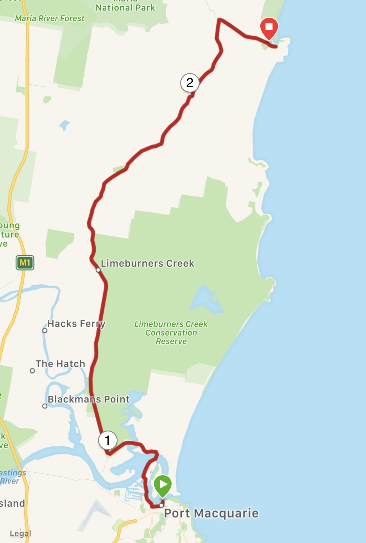
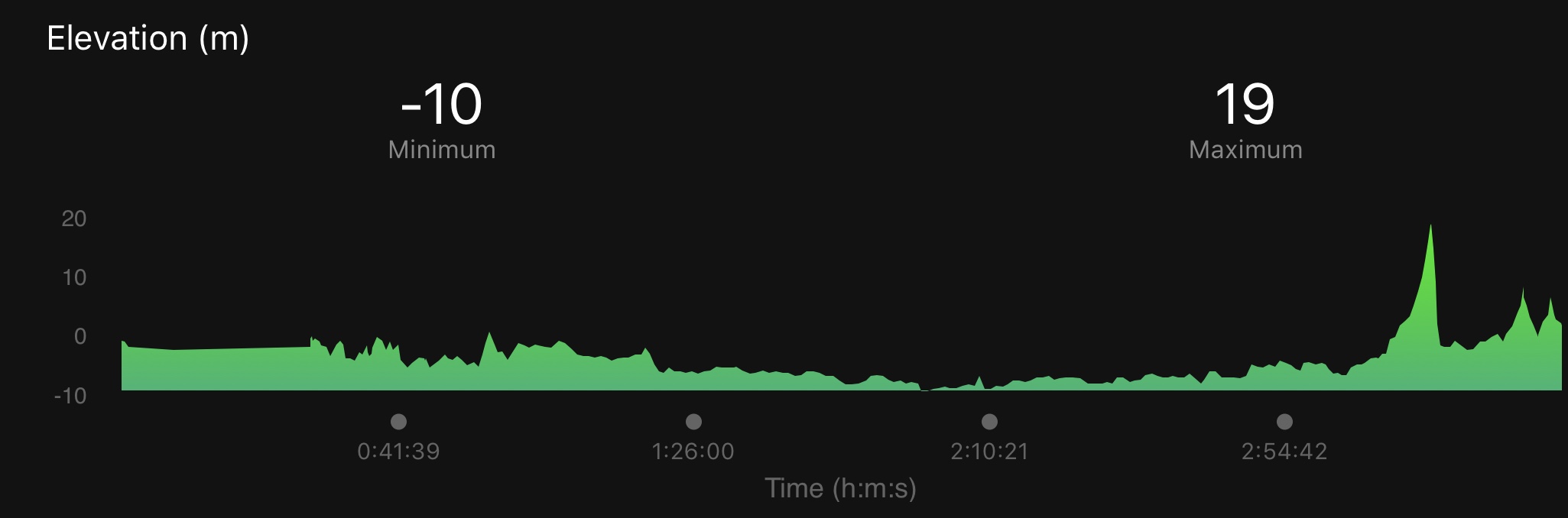
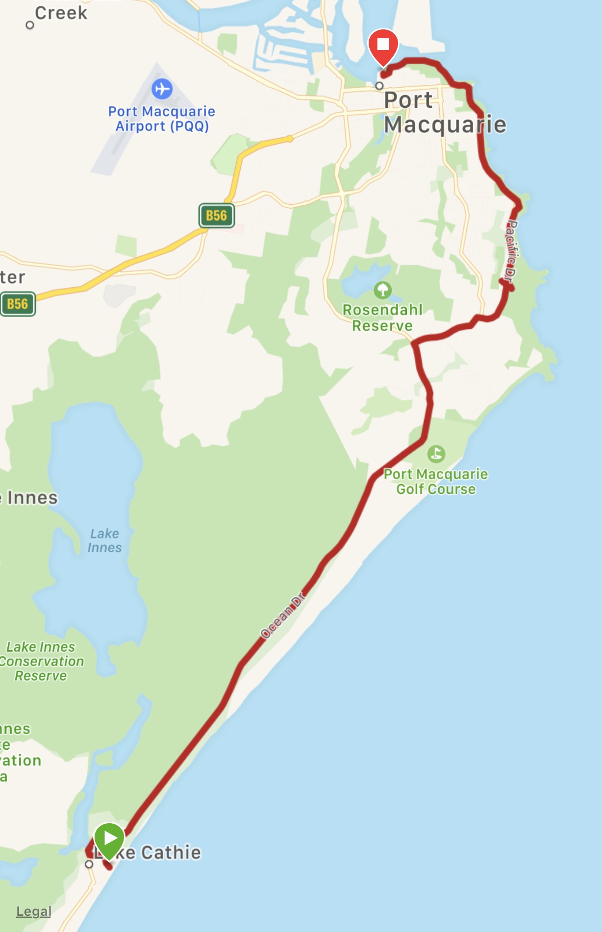
Port Macquarie to Crescent Head – 42.5 km (by bike)
We are on the traditional territory of the Dunghutti People
Today was Wayne’s birthday and we celebrated with Helen over breakfast at Casualties.
We had planned a short distance again today as the route included another long stretch of unsealed road and we are also a bit restricted in terms of accommodation options in this section of the route.
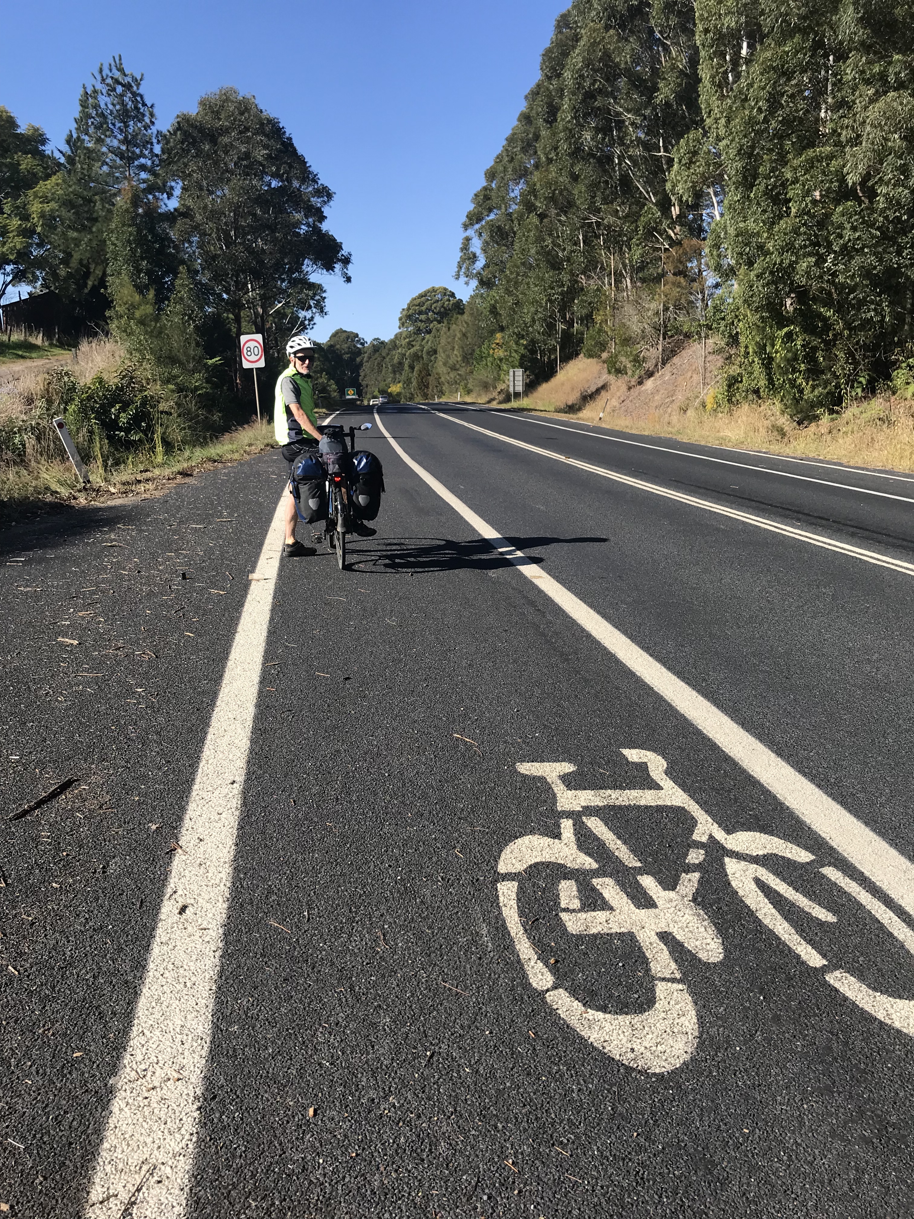
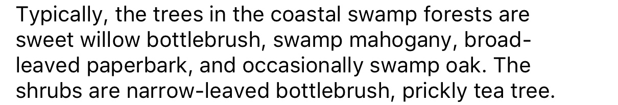
Just out of the town we took a short cable ferry trip over the Hastings River (no charge for bikes or pedestrians). Soon after disembarking, Lois and Wayne were surprised by a kangaroo hopping down a driveway and across the road in front of Wayne’s bike! We all saw more kangaroos later, not in the park where we were expecting, but grazing on farmers’ fields.
The unpaved Maria Road runs for 24km along the western boundary of Limeburner’s Creek National Park and then along the eastern boundary of Maria National Park. Limeburners refers to the early days of European settlement when oyster shells from the creek were burned to produce lime for mortar.
CycleWayz
The road surface was a mix of corrugations, rough gravel and, for a time, graded dirt. It was slow and quite tiring from constant jarring, as we traversed ranch land, scrub, coastal swamp forest
CycleWayz
and large plantations of small trees. We learned later that these were tea trees, used for the production of two essential oils. The effectiveness of the oil for the treatment of skin infections is questioned in a Wikipedia article.
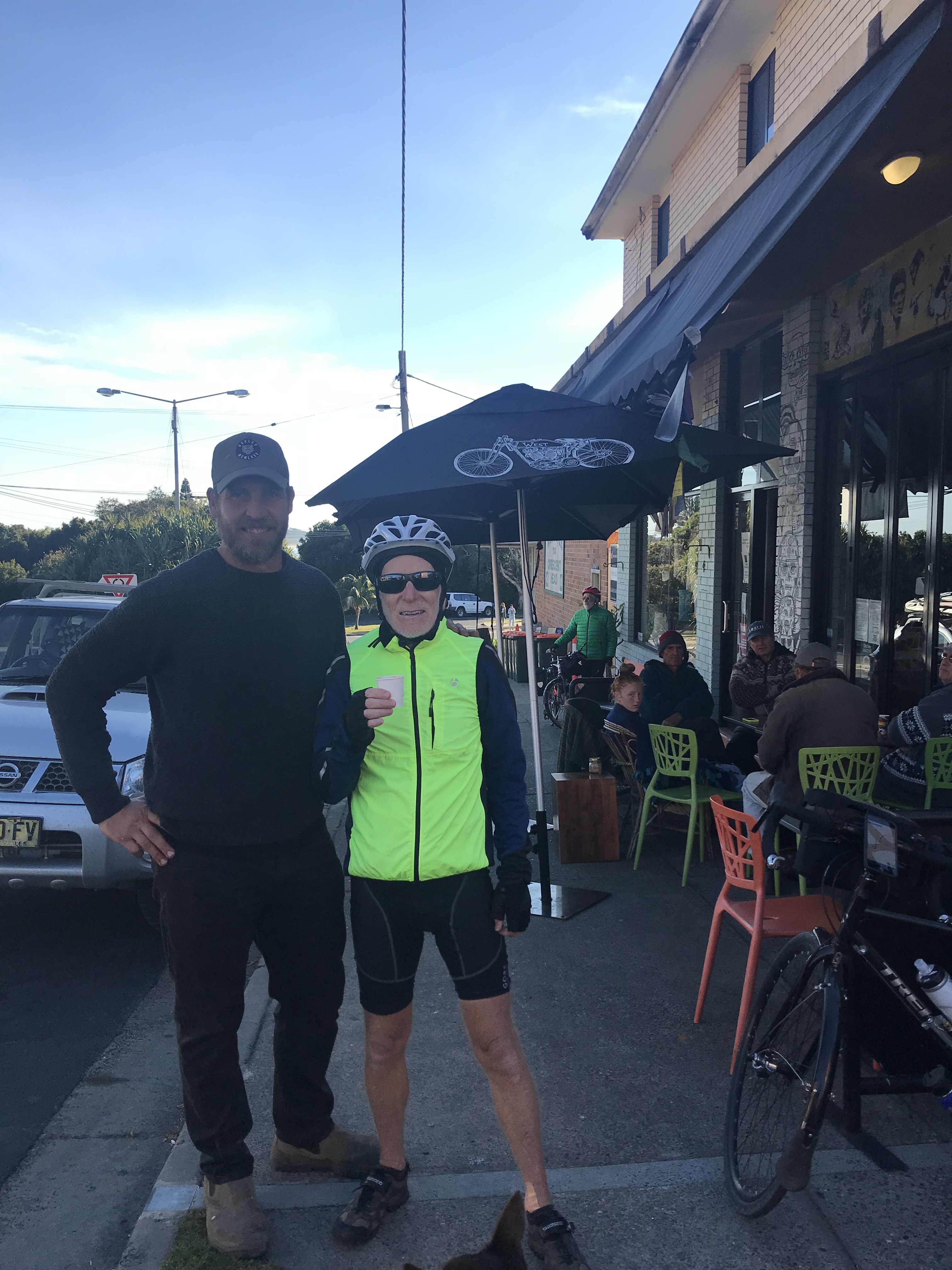
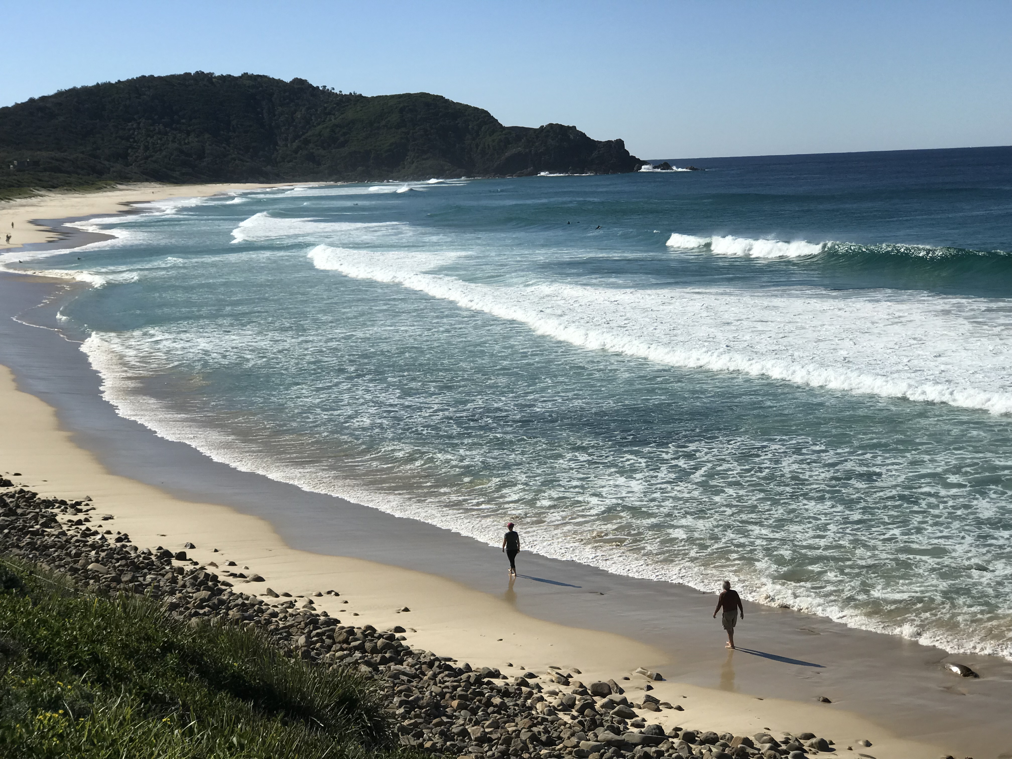
Relieved to be back on tarmac, we were soon in Crescent Head. As we were too early to check in to our motel, we had some lunch at Barnett’s Bakery, threw some laundry into a machine at a laundromat down the street, and then cycled down to the beach for a view. From Little Nobby, an endless white sandy beach stretches towards Hat Head to the north and, to the south, the rocky cliffs of the headland. Crescent Head is famous for its legendary “right hand surf breaks”.
An early dinner of fish (flathead and NZ hoki) and chips at Hooked left us feeling the need to get back on our bikes!
The first successful land claim under the Native Title Act was made by the Dunghutti people in 1997, concerning a parcel of land at Crescent Head that had been used for residential development. The Crescent Head Agreement recognizes the native title rights of the Dunghutti people, including the exclusive right to possession, occupation and enjoyment of the land and, where title has been extinguished, to compensation, in this case, $6.1 million. Since 2014, the Dunghutti people have been working on a blanket land claim for all vacant crown land in the Dunghutti tribal area which extends from the Oxley Wild Rivers National Park at the head of the Macleay River, north to Yarrapinni Mountain and south as far as Walcha, inland from Crescent Head.
We are on the traditional territory of the Biripi People
This morning we prepared breakfast in our apartment overlooking the sea; muesli and Tasmanian Greek yogurt (our favourite), scrambled eggs, toast and espresso (tea for Wayne).
It was a short ride along Ocean Drive/Pacific Dive towards Port Macquarie, becoming hillier with more traffic and narrower shoulders as we progressed.
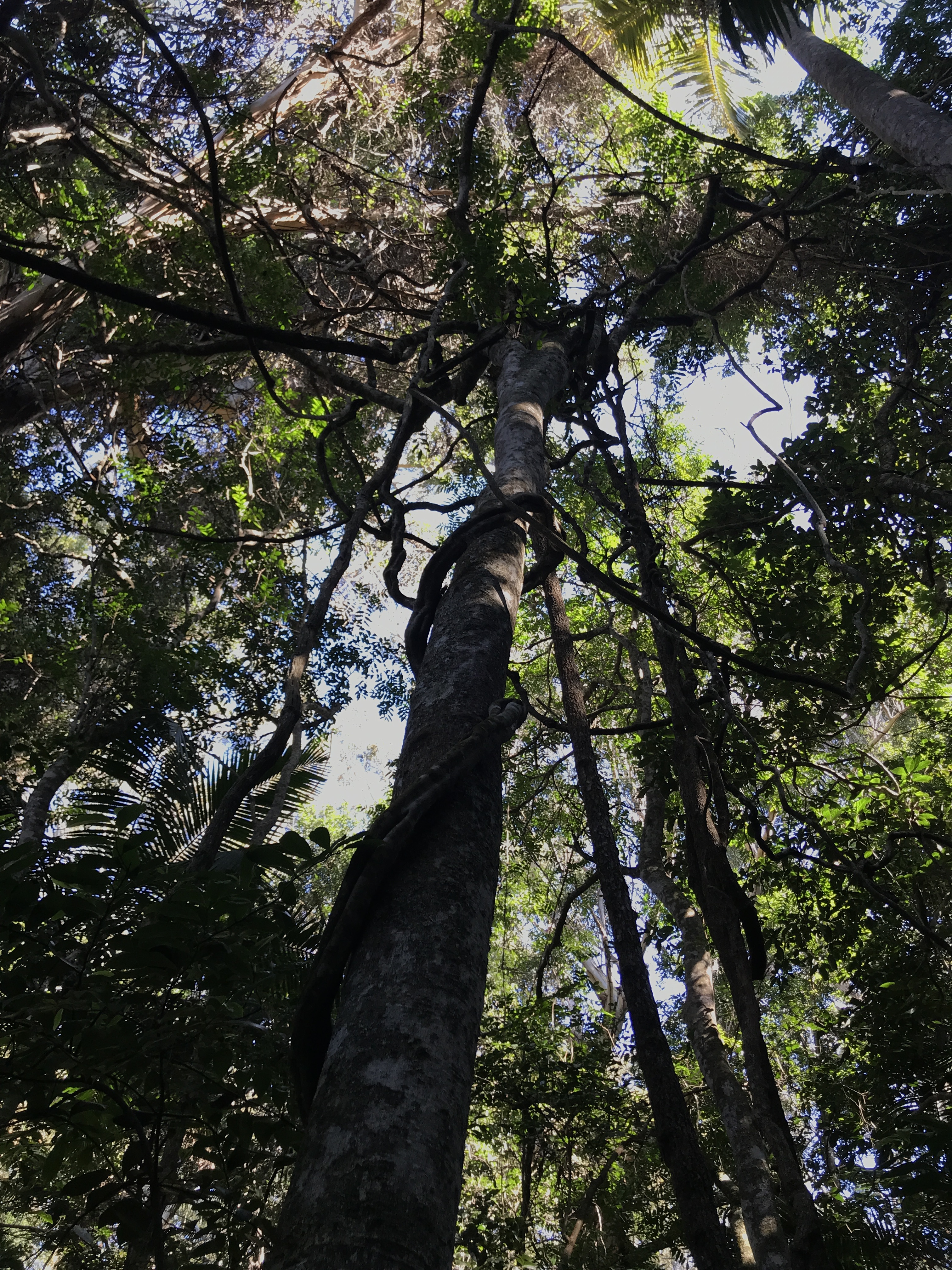
We visited the Sea Acres Rainforest Centre, where we had coffee in the Rainforest Cafe and then walked the 1.3 km boardwalk 7 metres above the forest floor through the canopy of the remnant seaside rainforest (much of this type of coastal rainforest has been lost to agriculture, mining or residential development.) The fifty eight signs on the walk highlighted the bewildering variety of palms, ferns, vines, eucalyptus and many other trees. We were impressed by the strangler fig which begins life as a seedling which grows on other plants (epiphyte) or on rocks (lithophyte) and can grow to a height of 60 m and nearly as wide, eventually causing the demise of its host tree.
Back on our bikes, the route took us up and down past rocky shores and sandy beaches and finally on a cycle path along the Hastings River to our hotel.
Helen joined us again after a long train and bus journey from Newcastle. She will hook up with us again in Coff’s Harbour as she begins to travel north ahead of us. We had a Michelin-worthy meal together at Bill’s Fishouse (Lonely Planet recommendation), which included Tasmanian wild salmon, Kingfish, scallops, fish pie, fresh herb and greens salad, local olives and David Hook Hunter Valley Pinot Grigio.
We are on the traditional territory of the Biripi People
An espresso, a flat white, English Breakfast tea
plus an Aussie pie for Wayne from Harrington Bakehouse helped start our day. Lois gave the server our card and we were on our way again along Crowdy Head Road, passing the breakwater at the mouth of the Manning River. At the turnoff to Crowdy Bay National Park, Wayne headed off along the unsealed road, while we did a side trip part way up the headland at Crowdy Bay to be rewarded with a spectacular view looking north to Diamond Head.
CycleWayz
Returning to the Crowdy Bay Road turnoff, we cycled along the packed dirt road for 24 km through the park, parallel to the bay, passing by John’s State forest. The road surface wasn’t too bad except near the end when it turned to rough gravel.
CycleWayz
While we were having a break on the side of the road, a park ranger stopped to ask us how we were doing. In response to our inquiries about the possibility of kangaroo sightings, he told us that wallabies were more common in the particular sparser habitat we were riding through, but that they were harder to see! He suggested we would be more likely to see kangaroos in the Diamond Head campsite, where he’d seen a dozen the day before.
As we moved out of grasslands into woodland of eucalyptus, blackbutt, brush box and paper brush trees, our app indicated this was one of the best places to get close to an eastern Grey kangaroo or an elusive koala bear. Our necks grew stiff from peering up into the canopy as we cycled, but the shy marsupial continued to elude us. The variety of birds and bird songs, however, was rich and wonderful. Paul added the Channel-billed Cuckoo to his list.
At the Diamond Head campsite turnoff, we found Wayne’s safety vest strategically placed on the sign, giving us another reason to cycle into the campsite. We found Wayne relaxing on a bench looking out on yet another vista of white sandy beach stretching for miles. Just as we were all setting off again, Paul happened to spy a group of kangaroos munching on grass at the edge of the campsite. The animals were quite tame and did not seem to mind our approaching them. One was carrying a Joey!
Outside the park, the main road was quite busy, with little or no hard shoulder. Stopping for tea in Laurieton, we met two cyclists from Dorchester (UK), Holly and Conrad, who had cycled from Britain to Singapore and, in Australia, were cycling from Cairns to Melbourne. We were interested to hear their confirmation of the heavy traffic on the highway from Cairns to Brisbane, a route we had earlier contemplated doing.
Climbing up near Bonny Hills, Lois spotted a bird of prey wheeling over the brush. Paul then added a Square-tailed Kite to his list!
Our smart accommodation in Lake Cathie overlooked the beach, and included a hot tub with a view of the surf!
Wildlife note: possible Bandy Bandy snake (Lois, who freaked out and swerved away from it, cannot confirm absolutely that it was a snake and not a piece of striped tubing)
We are on the traditional territory of the Biripi People
Paul wanted to have coffee at Cafe 1 Twenty 3, as he was curious about the Holy Goat coffee advertised out front. The only reference Paul recalls to a “holy goat” was Rowan Atkinson’s blessing inFour Weddings and a Funeral! The barrista did not appear to know who Rowan Atkinson is or what Paul was talking about! She did say that legend has it that a goat discovered coffee beans in 600 AD! Whatever the background to the name, it comes from a roasterie in Port Macquarie and was very good.
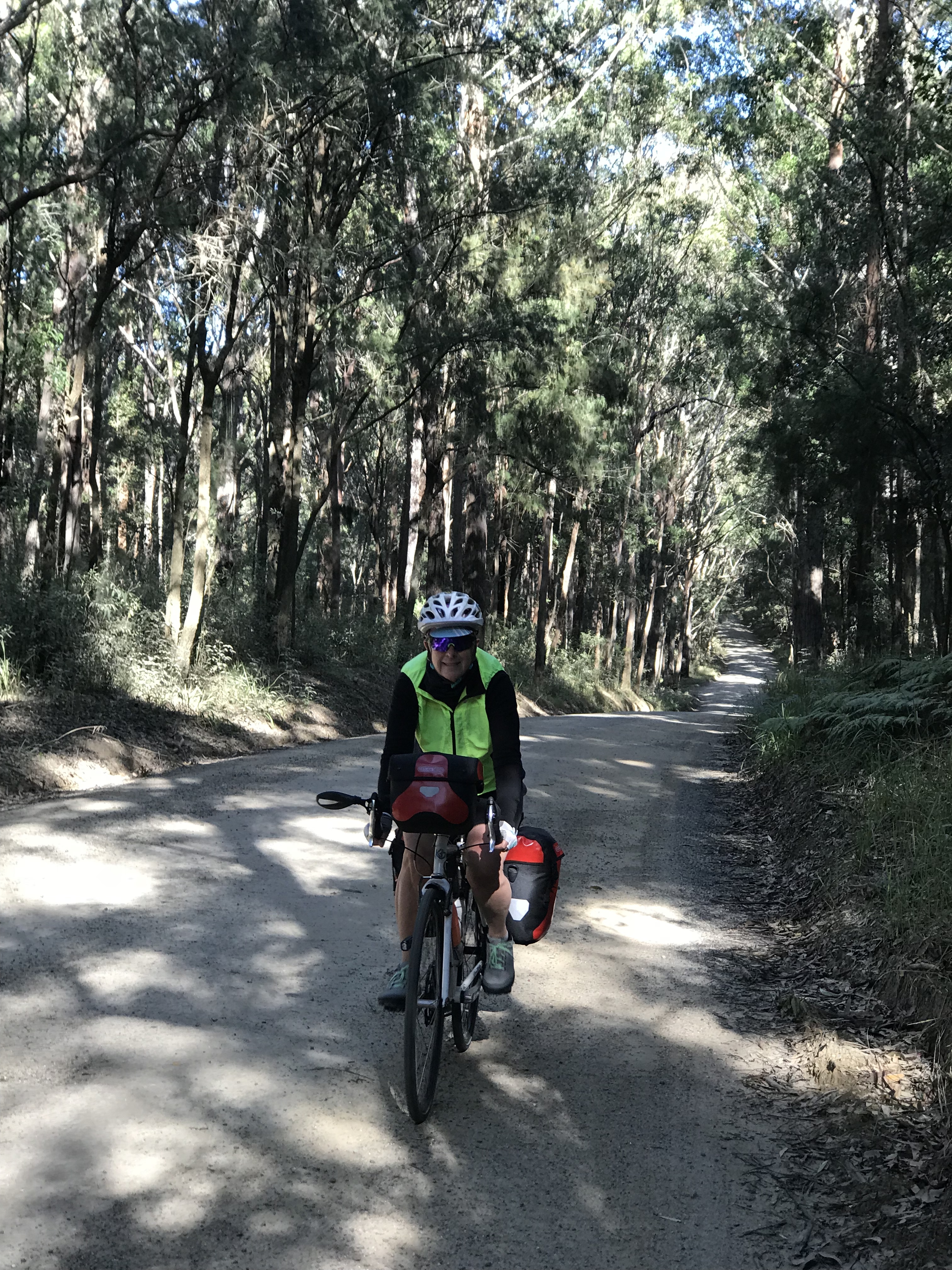
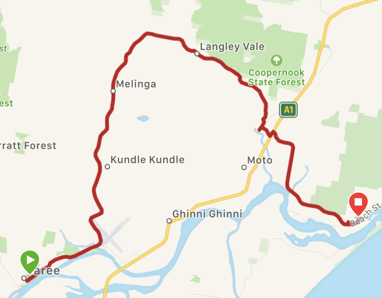
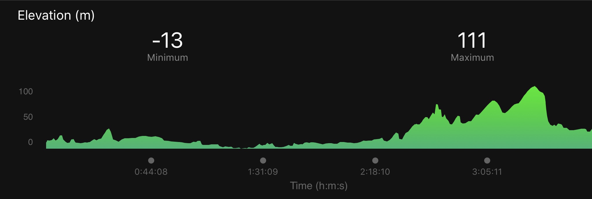
It was a short and easy ride today on the scenic route north of the highway, through the villages of Lansdowne and Coopernook to Harrington. The sun shone brightly again, the temperature climbing from a cool 5C when we started to around 20 C by noon. We cycled past rolling farmland, once logged for shipbuilding in Coppernook, now primarily pasture for cattle, sheep and horses. Beyond the fields we could see the hills of Coorabakh National Park which is the traditional territory of the Ngaamba People.
The Coopernook Church has an interesting history:
Our motel tonight is on the Manning River, the largest undammed river in Australia and one of the few to be fed by melting snow. The river is a large producer of Australian oysters and is home to many estuary fish, the most common the dusky flathead. Apparently, the river is frequented by dolphins and sharks and, occasionally whales. We have not spotted any.
We are on the traditional territory of the Biripi People
We had coffee with Helen at Kembali Cafe and then left her to catch the bus back to Newcastle, while we headed down Boomerang Drive to rejoin the route on the Lakes Way. The road followed a narrow peninsula between the ocean and Wallis Lake and through Booti Booti National Park, which encompasses part of Seven Mile Beach. This beach was used by Sir Charles Kingsford Smith in 1933 as the runway for the first commercial flight between Australia and New Zealand. Seven Mile Beach was also mined for mineral sands until 1975.
At Forster, where we stopped to buy a phone charger, Lois was interrogated by a very bright little boy of 7 of 8, who was intensely curious about what we were doing: “Where are you going? Where is your home? What’s in those bags? Is that your phone (Garmin)? Is that your husband? Where are you staying tonight?…”
We had a second coffee/tea in brilliant sunshine at Beach Bums Cafe overlooking the Forster Main Beach. Nine Mile Beach was in the distance!
The path continued into Tuncurry, joining the Lakes Way again soon after. From this point, the road was busy and the shoulder uncomfortably minimal. We did find a pleasant spot just below the highway at the edge of rolling farmland of pasture and trees for a picnic of cheese, crackers, eggplant dip, apples and nougat. Eventually, we turned onto the Pacific Highway which, despite its heavy truck traffic, is a divided highway with a good surface and a wide shoulder. We were happy to finally head off across the Manning River into Taree. The name Taree is derived from “tareebit” the local native Biripi word meaning tree by the river, or more specifically, the Sandpaper Fig.
We are on the traditional territory of the Worimi People
It was a cold 2oC when we left Hawks Nest at 7:30 am, fuelled with espressos and tea from the IGA coffee shop. We soon forgot the temperature as we pedalled through Myall Lakes National Park, rays of early morning sunlight filtering through the mist, accompanied by a cacophony of birdsong. We could hear the breakers and caught glimpses of the sand dunes from the road. At Hole in the Wall picnic area, we pushed our bikes up a path to get a view of the sea and the expansive Mungo beach. Myall Lakes National Park is part of the traditional territory of the Worimi people, who occupied the lands for at least 4000 years before they were “discovered” by Captain Cook in 1770. The park contains a number of middens and other cultural and spiritual sites important to the Worimi People. Here is an all too familiar history of the Worimi following European contact.
A local government website notes some of the traditional uses the Worimi made of local plants and animals:
Canoes were made from the bark of the Stringybark tree (Punnah) E. obliqua or She Oak. The ends were plugged with clay and when in use a fire always burned on a bed of clay at the back. Paddles made of seasoned hardwood were shaped like a large spoon and these paddles were used in a kneeling position from the middle of the 4.5m canoe. Fishing lines were made from the inner bark of young Kurrajong trees or Sally Wattle twisted, and rendered watertight by soaking in the sap of the Bloodwood tree. Women of the tribe had the first joint of their little finger removed to be dropped in the fishing grounds so that fish would be attracted to that hand. It was forbidden to fish if you had just eaten fruit.
Fishing spears were made from the flowering stem of the Gymea Lily or the Grass Tree and tipped with 4 prongs of ironbark, the lot was held together with yellowgum (grass tree). Boomerangs were made from wild Myrtle. The young flowering spikes of the Gymea Lily were roasted in the fire after a long soaking in water. The wild Cape Gooseberries that grew on Cabbage Tree Island were highly sought after. Fern root and daisy yam were eaten when fish were scarce.
The CycleWayz app route, which we have been following since Manly (except for the detour to Nelson Bay) took us on the Old Gibber Road and Mining Road Trail, a 20 km stretch of unsealed path. The area was mined for heavy mineral sands like rutile and zircon until the 1970’s when it was banned. For the most part, we were able to keep up a relatively good, but tiring, pace on the sand and gravel surface, which occasionally deteriorated to quite rocky and challenging.
After we regained a paved surface, it was an undulating pleasant ride past Myall and Smiths Lakes to Blueys Beach, stopping for tea and mango smoothies at Bungwahl on the way.
We were happily surprised by the arrival of Helen, who had come to spend our day off with us at Blueys Retreat resort! Today involved sleeping in, relaxing on the sunny patio of Kembali Cafe over coffee and lunch, walking the forest path to Boomerang beach and cooking supper together.
Wildlife notes:
Eastern grey kangaroo beside the road, spotted by Paul and Wayne. (Lois was looking into the forest for koalas at that moment.)
Sign outside the Kembali Cafe warning of swooping Kookaburras – there was one perched on a hydro line waiting…
Nelson Bay to Hawks Nest (16 km by ferry and bike)
We are on the traditional territory of the Worimi People
July 13: Nothing opened for breakfast before 7:30 am, so we packed up and parked our bikes outside Momas just as the doors were opening. Breakfasts were delicious full cream yoghurt and homemade granola, poached eggs and thick slices of sourdough bread. We then cycled back to the docks and caught the ferry across the harbour to Stockton, where a path took us along the North Channel of the Hunter River, past Newcastle airport and onto the B63 parallel to the Stockton Bight Sand Dunes. At a service station, where we had stopped to look for food for a picnic, we chatted with a man who gave us directions to a good bakery and told us that he had just seen a group of kangaroos near the road that we were to take. Unfortunately, we missed the kangaroos, but we did see an emu! We weren’t sure whether it was domesticated or wild, as it was near farmland and it rather tamely came across the field to check us out.
Saxby’s bakery/cafe was a bustling place, with a huge selection of Aussie pies, not all of which were meat-filled! We chose some to go and then Wayne and Lois each separately asked for what looked like cinnamon buns. This request met with a puzzled look until the server realized we were pointing to savory buns made with Vegemite! Down the road, we stopped at a small store advertising fresh avocados. In addition to various avocado-related kitchen items and other products, the shop sold different varieties of avocado and avocado oil. We bought 3 perfectly ripe locally grown Haas avocados, which, the proprietor assured us, had never been squeezed!
Eventually, we turned off on a road leading to Birubi Beach, the northern most section of the vast beach and sand dunes of the Worimi Conservation Lands. The view was spectacular. These lands cover 4,200 hectares, 1,800 hectares of which are forest, and 32 kilometres of the longest moving sand dunes in the southern hemisphere. “The dunes reach heights of over 40 metres with slopes up to 60 degrees which form a much sought after location for film makers”.
As we ate our lunch at a picnic table above the beach, looking our over the sea and sandscape , we spotted the spray of humpback whales currently migrating north. On land, large 4WD buses and camels carried tourists out on to the dunes.
Leaving the beach, we rode through Tomaree National Park. Posted signs warned drivers of koala bears crossing the road, but none were to be seen today. Nelson Bay was our destination where we will be taking a ferry across Karuah River tomorrow morning.
July 14: After discovering the night before that the 08:30 ferry to Tea Gardens is not running, we had to change plans. The first ferry leaves at 11:30 am, meaning we would not begin the 60 km ride to Blueys Beach until nearly 1:00 pm, too late to ensure arrival before sundown, currently around 5:00 pm. We quickly changed our hotel reservations and booked rooms for tonight at the Hawks Nest motel on the other side of the river.
The crew hoisted our bikes onto racks on the top deck while we piled in below with all our panniers and a full boat of passengers.The 50 year-old wooden boat, originally a military vessel in Sydney Harbour, runs a ferry service across the estuary of the Myall River to Tea Gardens and Hawks Nest on the northern side of Port Stephens. This area is popular for dolphin-sighting cruises and swimming with the dolphins. Approximately 150 bottlenose dolphins live in the estuary. Due to the presence of a large sandbar in the middle of the river, the ferry crossing took more than an hour, passing by a mangrove forest and saltmarsh. No dolphins were sighted.
We stopped in Tea Gardens (after the Australian Agricultural Company’s failed attempt at tea cultivation) for lunch on a sunny but chilly patio and then headed across the “Singing Bridge” (named for the sounds produced by strong south-westerly winds in the bridge railings) to our motel in Hawks Nest. On the way, we cycled around the perimeter of the Koala Reserve, hoping to spot one of these elusive (and nocturnal) creatures. The motel receptionist told us that the bears do not stay in the reserve, but prefer to move around to find eucalyptus and mahogany, their favorite food.
We are on the traditional territory of the Awabakal People
After a good breakfast at Cafe Macquarie, we set out on the Fernleigh Track Rail Trail. The historic 16 km-long trail is a super route through wetlands, forest and coastal heath, and is close to a 10,000 year-old sand dunes system and the sea. The railway opened in the late 1880’s to transport coal from mines in the Lake Macquarie area to the Port of Newcastle and the steelworks, and passengers between Belmont and Newcastle. The track traverses Glenrock State Conservation Area, Awabakal Nature Reserve and the Belmont Wetlands State Park.
The abundance of bird life that could be heard, but not seen, along the trail, was frustrating for Paul! One constant birdsong was the doorbell-like call of the Bell Miner. There was a gentle incline up to Whitebridge station and then it was downhill to the start of our route, which was mostly a bike path, into Newcastle. We joined Throsby Creek, where we stoped for espresso, tea and scones, and continued on to follow the Hunter River into the city.
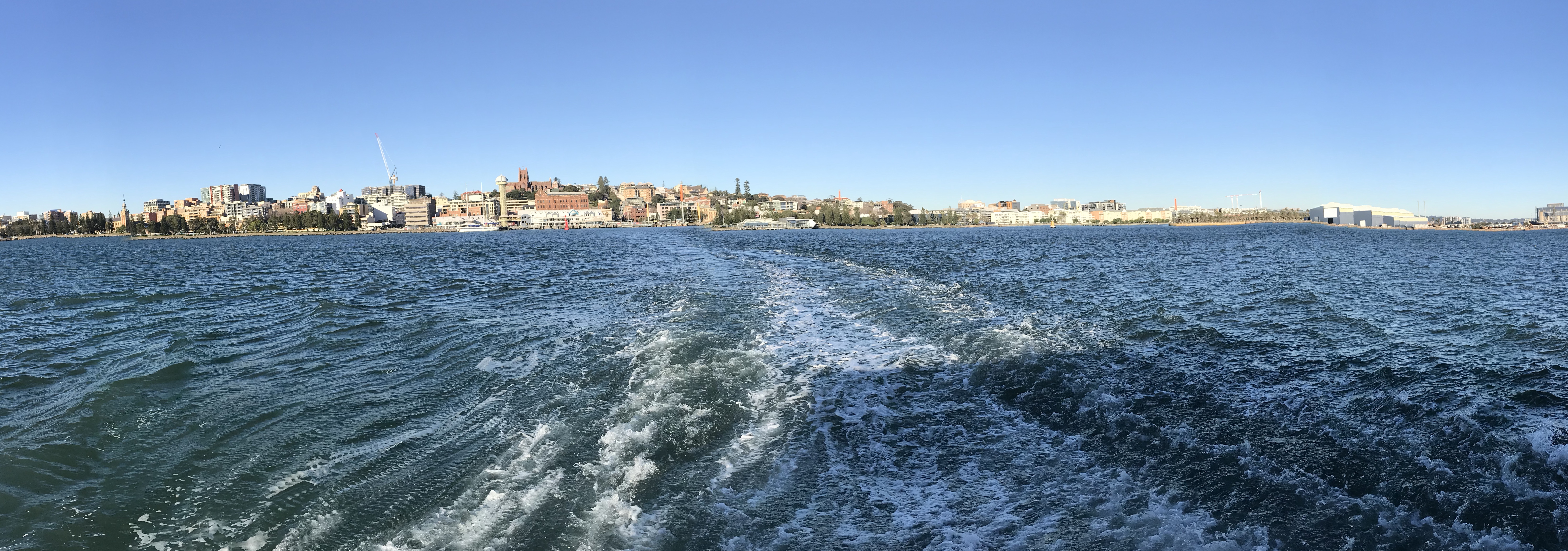
The port city of Newcastle, Australia’s second oldest city, was important as a centre for shipbuilding and steel in the past and is still the largest coal exporting harbour in the world. The downtown area is a mixture of old (original) and new architecture, with interesting conversions of old warehouses, rail workshops and banks. Work is currently underway to accommodate a light rail line.
While Wayne went in search of a bike shop, we visited the Newcastle Museum (very little on the history of the Awabakal and Worimi peoples, who traditionally occupied this area) and the Newcastle Art Gallery. The exhibit, Hunter Red: Corpus, was an intriguing group of works “unified by themes of the body represented in different and arresting ways – controlled, out of control, stolen, the abject of “other”.”
At dinner, Lois sampled a glass of local Hunter Valley Shiraz which got the thumbs up!
We are on the traditional territory of the Awabakal People
Today was Lois’ birthday and we all got a present: great bike paths, less traffic on the main roads, decent hard shoulders, and sunshine!
Lorraine’s birthday card to Lois!
After 5 km on the Central Coast Highway and a detour to watch the breakers at Bateau Beach, we followed a lovely cycle path alongside Tuggerah Lake. This is a saltwater lagoon, joined to the sea through a small tidal channel at a town suitably named “The Entrance”. Concerns about the effects of urbanization on such lakes has prompted efforts to improve the quality of the shoreline and water. The cycle path along the lake edge is part of this revitalization. We had a second coffee (tea for Wayne) and breakfast overlooking the water near the bridge at The Entrance. The route continued on the path through the Wyrrabalong National Park which preserves the last patch of coastal rainforest on the Central Coast. Bird sounds (mostly unidentifiable) were constant. Later there was a sign warning of kangaroos on the highway, but we have yet to see one.
At the Lizzy Bay Takeaway, we sat outside and ate fish and veggie burgers for lunch. Riding through the Munmorah State Conservation Area on a quiet road afterwards, we caught glimpses of the sea on one side and the inland lakes, including Lake Munmorah on the other.
Eventually, we joined the Pacific Highway and cycled on a wide hard shoulder for 11 km before turning off on another bike path which brought us to within a short distance of our motel on Lake Macquarie (Awaba), the largest coastal saltwater lagoon in Australia.
We celebrated Lois’ birthday over dinner at the Lake Macquarie Yacht Club.
We are on the traditional territory of the Ku-ring-gai People
It was a bit of a tough day, with lots of hills and constant traffic on the Central Coast Hwy, but no continuous hard shoulder. Although not winter by Canadian standards, the nighttime temperature drops to around 6 or 7 degrees on the NSW coast, so hats and gloves were needed for the first few kilometres. Just after leaving the motel, we were back on the already busy highway, facing a steep climb. Paul started cycling up the hill, Lois rode part way up on a sidewalk and Wayne discovered an alternate path that took him along the sea. But, the path ended at two sets of steps. One young man helped Wayne carry his bike up the first steps and then a second man hoisted the bike on his shoulders, panniers and all and carried it up the second flight!
We got to the Palm Beach ferry just in time to catch the 9:15 sailing. Even though we were the last to board, a member of the crew offered to take our photo out on the dock before we set off. Normally, this ferry goes to Ettalong Bay, but due to silting up of the channel it is currently diverted to Patonga. This is unfortunate as it added 11 km to our route plus a long (although quiet) steep hill! A tea stop at Terrigal with a view of the beach and the surf helped to restore morale and we braved the final stretch of highway traffic to reach our motel before sunset at 5:00 pm.
We took a cab to a local hotel for dinner where we got involved in a trivia game!
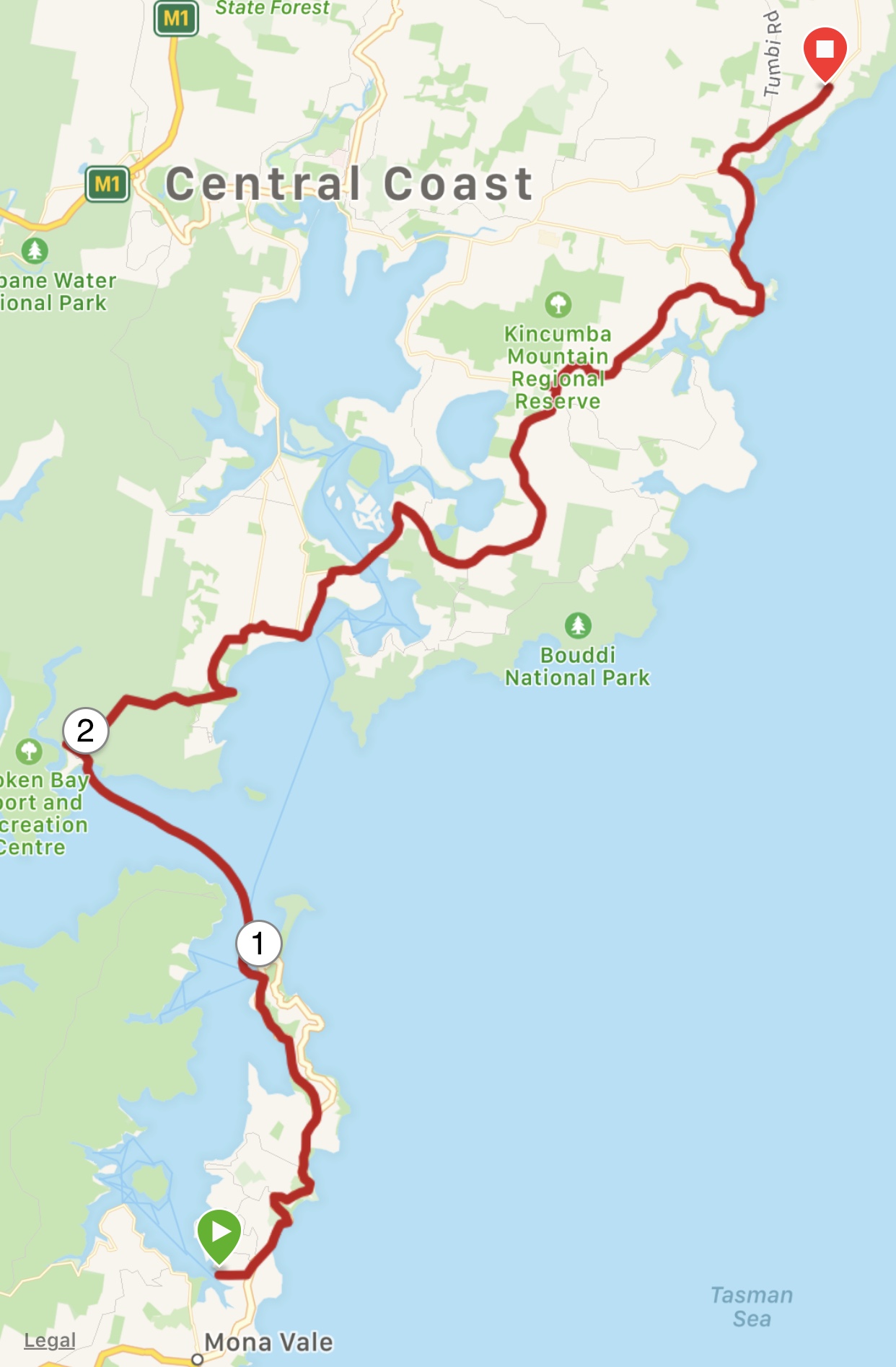
Sydney to Newport – 36 km (25 by bike, 11 by ferry)
We are on the traditional territory of the Ku-ring-gai People
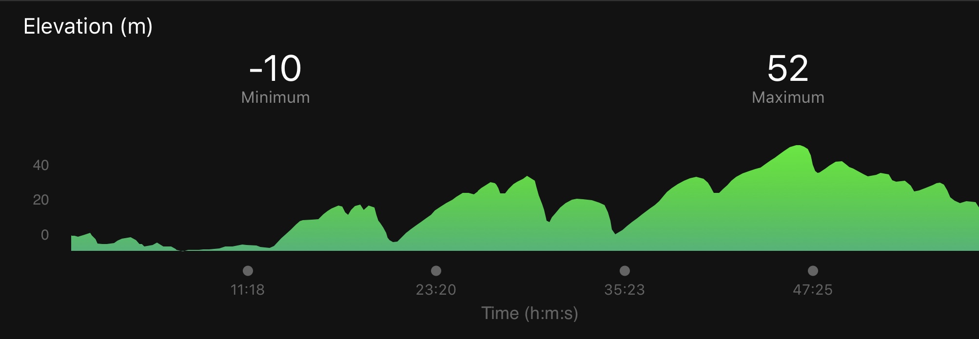
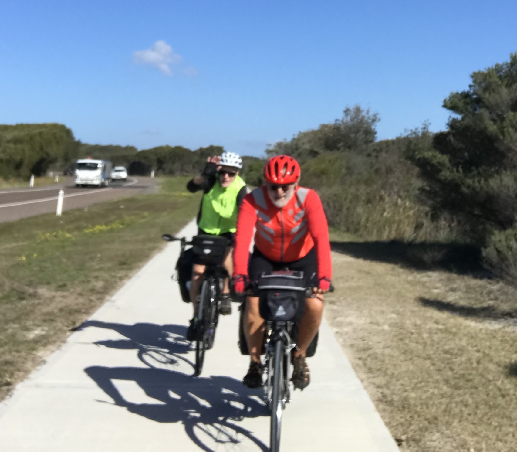
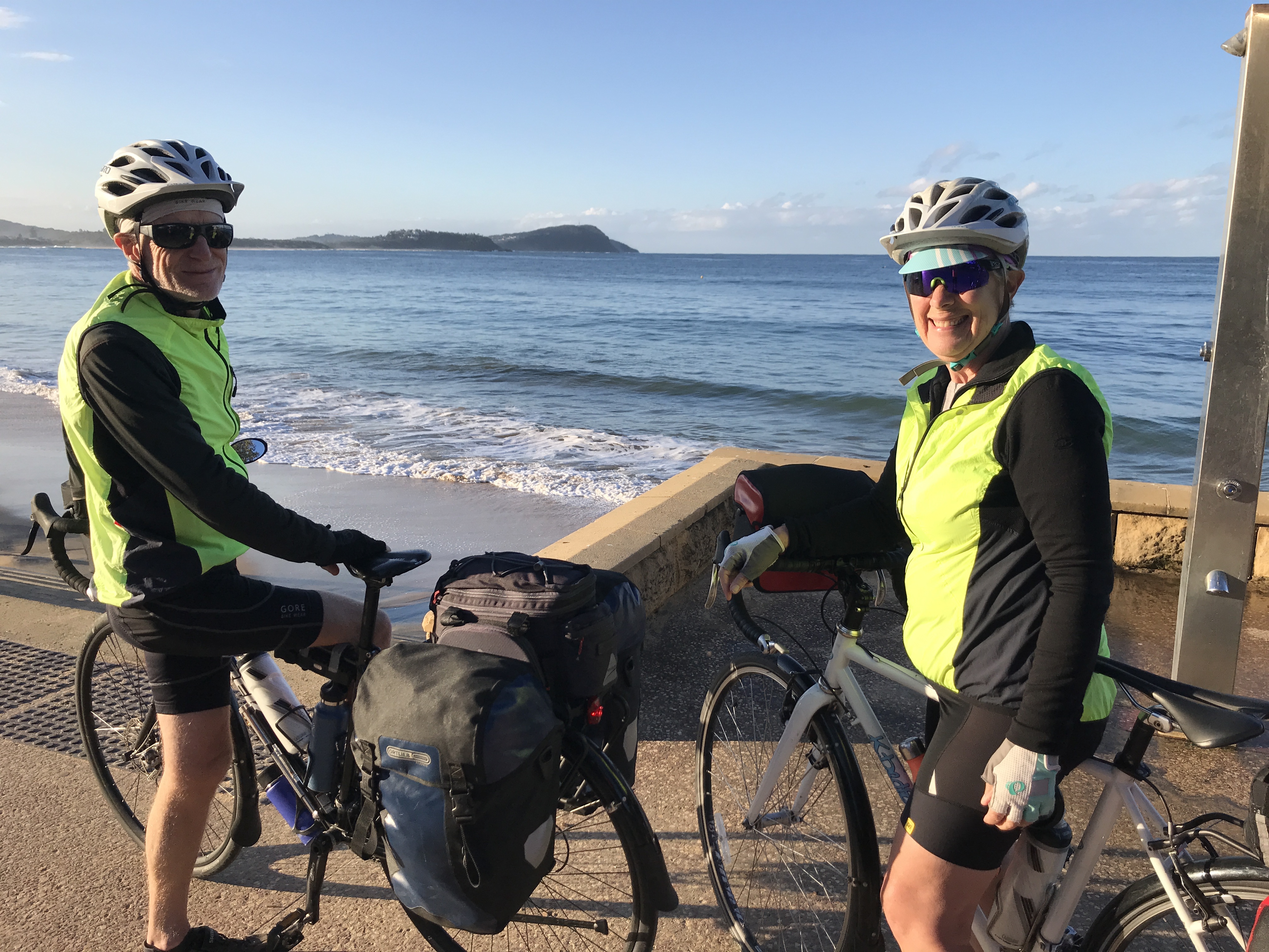
It’s been nearly a month since we were on our bikes, so we were anxious to begin our cycle trip to Brisbane today, joined on this leg by our old friend Wayne Balanoff. The route will generally follow the Pacific Highway.
Wayne picked up his bike, which had been re-assembled at Woolys Wheels. After some adjustments and an an initial ride back to the hotel, we were all set to leave. Helen met us at Circular Quay when we had threaded our way through Sydney morning traffic, along some good bike paths and across the park by the Art Gallery of New South Wales.
The ferry crossing to Manly was a bit rough at times so we had to keep an eye on our bikes! We had coffee together on the dock at Manly, then said goodbye to Helen and headed north to Newport. Luckily for us, the wind was from the west and mostly behind us.The traffic was quite heavy on the Pacific Highway but we managed to get off it for a few kilometres and also headed down to Fishermen’s Beach after lunch to watch significant breakers crashing onto the beach in the sunshine. We left the highway again to take a rather hilly bike route closer to the sea, eventually descending to Newport Harbour and our hotel. Being Monday, most restaurants were closed, but a local Thai restaurant served decent food with friendly service (and only a $2 BYOB charge – Wayne and I went across the street for a bottle of Australian Merlot).
“The Big Matchsticks”. Almost Once by Brett Whiteley